
Scientific Name
Rachycentron canadum
Common Names
Ling
Lemonfish
Stock Status
Overfishing – Yes
Overfished – No
Recreational Regulations
Federal Regulations
-
Open year-round
- 1 Bag Limit
- 2 Vessel Limit
- Minimum Size: 36 in Fork Length
Notes:
The 2-day bag limit allowance for charter vessels and headboats does not apply to cobia.
For more information, see GulfCouncil.org
The sale of recreationally harvested cobia is prohibited by existing state law in each Gulf state.
To see commercial regulations, download Fish Rules Commercial App for iOS devices or Android devices.
Commercial Regulations
Spanish Mackerel Permit – Gulf of Mexico
-
Open year-round
- 2 qty Fish per Vessel per Day Trip Limit
- Quota: Commercial ACT – 1,564,920 lbs MW
0.2% harvested Notes:
There is a 1-fish per person bag limit in addition to the two fish per vessel limit.
Dealers with a federal Gulf or South Atlantic dealer permit can only purchase cobia harvested in federal waters in the Gulf of Mexico or the Florida East Coast Zone from a vessel with at least one of the following federal permits:
- Commercial Spanish Mackerel Permit
- Commercial King Mackerel Permit
- Coastal Migratory Pelagics Charter/Headboat Permit
Areas
Alabama Alps Reef
Alabama Alps Reef HAPC is bounded by rhumb lines connecting the following points in order: 29°16.160′ 88°20.525′ 29°15.427′ 88°18.990′ 29°13.380′ 88°19.051′ 29°14.140′ 88°20.533′ 29°16.160′ 88°20.525′Deployment of a bottom longline, bottom trawl, buoy gear, dredge, pot, or trap, and bottom anchoring by fishing vessels are prohibited year-round in the area of the HAPC.
AT 047
AT 047 HAPC is bounded by rhumb lines connecting the following points in order: 27°54.426′ N 89°49.404′ W27°54.486′ N 89°46.464′ W27°51.874′ N 89°46.397′ W27°51.814′ N 89°49.336′ WDeployment of a bottom longline, bottom trawl, buoy gear, dredge, pot, or trap and bottom anchoring by fishing vessels are prohibited year-round in the HAPC.
AT 357
AT 357 HAPC is bounded by rhumb lines connecting the following points in order: 27°36.259' N 89°43.068' W 27°36.315' N 89°40.136' W27°33.703' N 89°40.073' W27°33.646' N 89°43.004' WDeployment of a bottom longline, bottom trawl, buoy gear, dredge, pot, or trap, and bottom anchoring by fishing vessels are prohibited year-round in the HAPC.
East Flower Garden Banks
East Flower Garden Bank is bounded by rhumb lines connecting, in order, the following points: 27°59′14.4″ N 93°38′58.2″ W27°59′14.4″ N 93°34′03.5″ W27°52′36.5″ N 93°34′03.5″ W27°52′36.5″ N 93°38′58.2″ W27°59′14.4″ N 93°38′58.2″ WDeployment of bottom longline, bottom trawl, buoy gear, dredge, pot, or trap and bottom anchoring by fishing vessels is prohibited year-round.
EEZ Tortugas North
The area is bounded by rhumb lines connecting the following points: From point A at 24°40′00″ N. lat., 83°06′00″ W. long. to point B at 24°46′00″ N. lat., 83°06′00″ W. long. to point C at 24°46′00″ N. lat., 83°00′00″ W. long.; thence along the line denoting the seaward limit of Florida's waters, as shown on the current edition of NOAA chart 11434, to point A at 24°40′00″ N. lat., 83°06′00″ W. long.Fishing for any species and bottom anchoring by fishing vessels is prohibited year-round.
Florida Middle Grounds
Florida Middle Grounds HAPC is the area bounded by rhumb lines connecting the following points: 28°42.5′ N 84°24.8′ W28°42.5′ N 84°16.3′ W28°11.0′ N 84°00.0′ W28°11.0′ N 84°07.0′ W28°26.6′ N 84°24.8′ W28°42.5′ N 84°24.8′ WDeployment of bottom longline, bottom trawl, dredge, pot, or trap is prohibited year-round.
Green Canyon 852
Green Canyon 852 HAPC is bounded by rhumb lines connecting the following points in order: 27°08.354′ 91°08.929′; 27°05.740′ 91°08.963′; 27°05.762′ 91°10.610′; 27°08.376′ 91°10.567′; 27°08.354′ 91°08.929′.Deployment of a bottom longline, bottom trawl, buoy gear, dredge, pot, or trap, and bottom anchoring by fishing vessels are prohibited year-round in the HAPC.
Harte Bank
Harte Bank HAPC is bounded by rhumb lines connecting the following points in order: 26°40.826′ 96°36.590′; 26°40.789′ 96°32.220′; 26°37.992′ 96°32.308′; 26°38.043′ 96°36.636′; 26°40.826′ 96°36.590′.Deployment of a bottom longline, bottom trawl, buoy gear, dredge, pot, or trap, and bottom anchoring by fishing vessels are prohibited year-round in the HAPC.
L&W Pinnacles and Scamp Reef
L & W Pinnacles and Scamp Reef HAPC is bounded by rhumb lines connecting the following points in order: 29°18.595′ 87°48.757′; 29°18.484′ 87°50.688′; 29°19.754′ 87°52.484′; 29°20.401′ 87°51.449′; 29°20.095′ 87°50.933′; 29°20.832′ 87°46.631′; 29°21.473′ 87°46.326′; 29°21.314′ 87°45.535′; 29°22.518′ 87°43.465′; 29°21.144′ 87°42.632′; 29°19.269′ 87°45.525′; 29°18.595′ 87°48.757′.Deployment of a bottom longline, bottom trawl, buoy gear, dredge, pot, or trap, and bottom anchoring by fishing vessels are prohibited year-round in the area of the HAPC.
Madison Swanson
The Madison and Swanson sites are bounded by rhumb lines connecting, in order, the following points: 29°17′ 85°50′; 29°17′ 85°38′; 29°06′ 85°38′; 29°06′ 85°50′; 29°17′ 85°50′.Fishing prohibited year-round. Possession of reef fish prohibited even for vessels in transit unless the vessel has an operating vessel monitoring system, a valid federal commercial Gulf of Mexico Reef Fish Permit, and fishing gear is appropriately stowed. These prohibitions do not apply to Atlantic Highly Migratory Species.
McGrail Bank
McGrail Bank HAPC is bounded by rhumb lines connecting, in order, the following points: 27°59′06.0″ 92°37′19.2″; 27°59′06.0″ 92°32′17.4″; 27°55′55.5″ 92°32′17.4″; 27°55′55.5″ 92°37′19.2″; 27°59′06.0″ 92°37′19.2″.Deployment of bottom longline, bottom trawl, buoy gear, pot, or trap and bottom anchoring by fishing vessels is prohibited year-round.
Mississippi Canyon 118
Mississippi Canyon 118 HAPC is bounded by rhumb lines connecting the following points in order: 28°53.183′ 88°30.789′; 28°53.216′ 88°27.819′; 28°50.602′88°27.782′; 28°48.944′ 88°27.759′; 28°48.962′ 88°30.727′; 28°53.183′ 88°30.789′.Deployment of a bottom longline, bottom trawl, buoy gear, dredge, pot, or trap, and bottom anchoring by fishing vessels are prohibited year-round in the HAPC.
Pulley Ridge
Pulley Ridge HAPC is bounded by rhumb lines connecting the following points: A 24°58′18″ 83°38′33″; B 24°58′18″ 83°37′00″; C 24°41′11″ 83°37′00″; D 24°40′00″ 83°41′22″; E 24°43′55″ 83°47′15″; A 24°58′18″ 83°38′33″.Deployment of bottom longline, bottom trawl, buoy gear, pot, or trap and bottom anchoring by fishing vessels is prohibited year-round.
Pulley Ridge South Portion A
Pulley Ridge South Portion A HAPC is bounded by rhumb lines connecting the following points in order: 24°40.000′ 83°41.366′; 24°39.666′ 83°42.648′; 24°47.555′ 83°55.240′; 24°57.065′ 83°48.405′; 24°52.859′ 83°41.841′; 24°43.917′ 83°47.250′; 24°40.000′ 83°41.366′.Deployment of a bottom trawl, buoy gear, dredge, pot, or trap, and bottom anchoring by fishing vessels are prohibited year-round in the HAPC.
Roughtounge Reef
Roughtongue Reef HAPC is bounded by rhumb lines connecting the following points in order: 29°27.596′ 87°37.527′; 29°27.621′ 87°31.552′; 29°25.007′ 87°31.539′; 29°24.981′ 87°37.510′; 29°27.596′ 87°37.527′.Deployment of a bottom longline, bottom trawl, buoy gear, dredge, pot, or trap, and bottom anchoring by fishing vessels are prohibited year-round in the HAPC.
Southern Bank
Southern Bank HAPC is bounded by rhumb lines connecting the following points in order: 27°26.923′ 96°31.902′; 27°26.989′ 96°30.881′; 27°25.958′ 96°31.134′; 27°25.958′ 96°31.892′; 27°26.923′ 96°31.902′.Deployment of a bottom longline, bottom trawl, buoy gear, dredge, pot, or trap, and bottom anchoring by fishing vessels are prohibited year-round in the HAPC.
Steamboat Lumps
Steamboat Lumps is bounded by rhumb lines connecting, in order, the following points: 28°14′ 84°48′; 28°14′ 84°37′; 28°03′ 84°37′; 28°03′ 84°48′'; 28°14′ 84°48′.Possession of Reef Fish prohibited year-round, except when in transit with fishing gear stowed. Possession of all fish is prohibited November through April, except when in transit with fishing gear stowed. All Fishing Prohibited with the exception of surface trawling which is allowed May through October.
Stetson Bank
Stetson Bank HAPC is bounded by rhumb lines connecting, in order, the following points: 28°10′38.3″ 94°18′36.5″; 28°10′38.3″ 94°17′06.3″; 28°09′18.6″ 94°17′06.3″; 28°09′18.6″ 94°18′36.5″; 28°10′38.3″ 94°18′36.5″.Deployment of bottom longline, bottom trawl, buoy gear, pot, or trap and bottom anchoring by fishing vessels is prohibited year-round.
The Edges
The Edges is bounded by rhumb lines connecting, in order, the following points: 28°51′ 85°16′; 28°51′ 85°04′; 28°14′ 84°42′; 28°14′ 84°54′; 28°51′ 85°16′.All fishing prohibited January through April. Possession of any fish species is prohibited January through April, except when in transit with fishing gear stowed.
Tortugas South
Tortugas South area is bounded by rhumb lines connecting, in order, the following points: 24°33′00″ 83°09′00″; 24°33′00″ 83°05′00″; 24°18′00″ 83°05′00″; 24°18′00″ 83°09′00″; 24°33′00″ 83°09′00″.Fishing for any species and bottom anchoring by fishing vessels is prohibited year-round.
Viosca Knoll 826
Viosca Knoll 826 HAPC is bounded by rhumb lines connecting the following points in order: 29°10.920′ 88°03.509′; 29°10.877′ 87°59.460′; 29°07.974′ 87°59.448′; 29°08.017′ 88°03.532′; 29°10.920′ 88°03.509′.Deployment of a bottom longline, bottom trawl, buoy gear, dredge, pot, or trap, and bottom anchoring by fishing vessels are prohibited year-round in the HAPC.
Viosca Knoll 862/906
Viosca Knoll 862/906 HAPC is bounded by rhumb lines connecting the following points in order: 29°07.640′ 88°23.608′; 29°07.603′ 88°20.590′; 29°03.749′ 88°20.554′; 29°03.734′ 88°22.016′; 29°02.367′ 88°21.998′; 29°02.281′ 88°24.972′; 29°07.568′ 88°25.044′; 29°07.592′ 88°25.044′; 29°07.676′ 88°25.045′; 29°07.640′ 88°23.608′.Deployment of a bottom longline, bottom trawl, buoy gear, dredge, pot, or trap, and bottom anchoring by fishing vessels are prohibited year-round in the area of the HAPC. This prohibition does not apply to a fishing vessel issued a Gulf royal red shrimp endorsement, as specified in §622.50(c), while the vessel is fishing for royal red shrimp.
West Florida Wall
West Florida Wall HAPC is bounded by rhumb lines connecting the following points in order: 26°28.835′ 84°47.955′; 26°28.816′ 84°46.754′; 26°10.471′ 84°42.076′; 26°10.528′ 84°44.577′; 26°25.028′ 84°47.986′; 26°25.100′ 84°47.980′; 26°28.835′ 84°47.955′.Deployment of bottom-tending gear (bottom longline, bottom trawl, buoy gear, dredge, pot or trap) and bottom anchoring by fishing vessels is prohibited year-round.
West Flower Garden Banks
West Flower Garden Bank is bounded by rhumb lines connecting, in order, the following points: 27°55′22.8″ 93°53′09.6″; 27°55′22.8″ 93°46′46.0″; 27°49′03.0″ 93°46′46.0″; 27°49′03.0″ 93°53′09.6″; 27°55′22.8″ 93°53′09.6″.Deployment of bottom longline, bottom trawl, buoy gear, dredge, pot, or trap and bottom anchoring by fishing vessels is prohibited year-round.
Conditions
Gillnet Restrictions for Spanish Mackerel
Mesh Size RestrictionsThe minimum allowable mesh size for a gillnet used to fish for Spanish mackerel is 3.5 inches stretched mesh.Gulf EEZ: a vessel with a gillnet on board with a mesh size less than 3.5 inches stretched mesh, may not possess on that trip any Spanish mackerel.South Atlantic or Mid-Atlantic EEZ: a vessel with a gillnet on board that has a mesh size less than 3.5 inches stretched mesh, may possess or land on the day of that trip no more than 500 pounds of incidentally caught Spanish mackerel. Restrictions in the EEZ North of 25°20.4′ N. lat. (Miami-Dade/Monroe County, Florida)On board a vessel with a valid Spanish mackerel permit that is fishing for Spanish mackerel or that possesses Spanish mackerel:No person may fish with, set, place in the water, or have on board a gillnet with a float line longer than 800 yd.No person may fish with, set, or place in the water more than one gillnet at any one time.No more than two gillnets, including any net in use, may be possessed at any one time, except for a vessel with a valid commercial vessel permit for Spanish mackerel engaged in a transfer.If two gillnets, including any net in use, are possessed at any one time, they must have stretched mesh sizes that differ by at least .25 inch, except for a vessel with a valid commercial vessel permit for Spanish mackerel engaged in a transfer, in which case the vessel may possess two gillnets of the same mesh size provided that one of the nets is transferred to that vessel.No person may soak a gillnet for more than 1 hour. The soak period begins when the first mesh is placed in the water and ends either when the first mesh is retrieved back on board the vessel or the gathering of the gillnet is begun to facilitate retrieval on board the vessel, whichever occurs first; providing that, once the first mesh is retrieved or the gathering is begun, the retrieval is continuous until the gillnet is completely removed from the water.The float line of each gillnet possessed, including any net in use, must have distinctive floats: the float line of each gillnet possessed, including any net in use, must have a maximum of nine distinctive floats, i.e., different from the usual net buoys, spaced uniformly at a distance of 100 yd or less. Each such distinctive float must display the official number of the vessel. Transfers in the EEZ North of 25°20.4′ N. lat. (Miami-Dade/Monroe County, Florida)A portion of a gillnet may be transferred at sea only in the EEZ and only from a vessel with a valid commercial vessel permit for Spanish mackerel that has exceeded the Spanish mackerel trip limit to another vessel with a valid commercial vessel permit for Spanish mackerel that has not yet reached the trip limit (the receiving vessel). Only one such transfer is allowed per vessel per day. In addition, to complete a legal transfer at sea, all of the following must apply:All fish exceeding the applicable commercial trip limit may not be removed from the gillnet until the transfer is complete. The fish transferred to the receiving vessel may not exceed the applicable commercial trip limit.The receiving vessel may possess no more than three gillnets on board after the transfer is complete.Prior to cutting the gillnet and prior to any transfer of Spanish mackerel from one vessel to another, the owner or operator of both vessels must contact NMFS Office for Law Enforcement, St Petersburg, Florida, phone: 1-727-824-5344.
Reporting
The owner or operator of a vessel that fishes for or lands coastal migratory pelagic fish for sale in or from the Gulf, Mid-Atlantic, or South Atlantic EEZ or adjoining state waters, or whose vessel is issued a commercial permit for king or Spanish mackerel, as required under §622.370(a)(1) or (3), respectively, who is selected to report, must maintain a logbook on a form available from NOAA Fisheries.These completed fishing records must be submitted to NOAA Fisheries postmarked no later than 7 days after the end of each fishing trip. If no fishing occurred during a calendar month, a report so stating must be submitted on one of the forms postmarked no later than 7 days after the end of that month. Information to be reported is indicated on the form and its accompanying instructions.Contact 305-361-4581 for assistance with commercial logbooks.
Harvest Limitations
A person who fishes in the EEZ may not combine federal harvest with harvest applicable to state waters. Species may not be transferred at sea.
Recreational Bag Limit
If the recreational sector for the applicable migratory group, zone, or gear is open, the bag and possession limits for Spanish mackerel apply to all harvest or possession for the closed species, migratory group, zone, or gear in or from the EEZ. If the recreational sector for the applicable species, migratory group, zone, or gear is closed, all applicable harvest or possession in or from the EEZ is prohibited.
Sale Purchase Restrictions
A king or Spanish mackerel harvested or possessed in the EEZ on board a vessel that does not have a valid commercial vessel permit for king mackerel, as required under §622.370(a)(1), or a valid commercial vessel permit for Spanish mackerel, as required under §622.370(a)(3), or a king or Spanish mackerel harvested in the EEZ or possessed under the bag limits specified in §622.382, may not be sold or purchased, except when harvested under the bag limits on board a vessel operating in the Gulf as a charter vessel or headboat and that vessel has both a valid Federal charter vessel/headboat permit for Gulf coastal migratory pelagic fish, as required under §622.370(b)(1), and a valid commercial vessel permit for king mackerel or Spanish mackerel, as required under §622.370(a)(1), as appropriate to the species harvested or possessed.Coastal migratory pelagic fish harvested in or from the EEZ or adjoining state waters by a vessel that has a valid Federal commercial vessel permit or a charter vessel/headboat permit may be sold or transferred only to a dealer who has a valid Gulf and South Atlantic dealer permit, as required under §622.370(c)(1).Coastal migratory pelagic fish harvested in or from the Gulf or South Atlantic EEZ may be first received by a dealer who has a valid Gulf and South Atlantic dealer permit, as required under §622.370(c)(1), only from a vessel that has a valid Federal commercial vessel permit, as required under §622.370(a), or a charter vessel/headboat permit for coastal migratory pelagic fish, as required under §622.370(b).Cut-off (damaged) king or Spanish mackerel. A person may not sell or purchase a cut-off (damaged) king or Spanish mackerel that does not comply with the minimum size limits specified in §622.380(b) or (c), respectively, or that is in excess.
Landing Fish Intact
Cut-off (damaged) king mackerel that comply with minimum size limits and trip limits may be possessed on vessels operating under trip limits and sold. A maximum of five additional cut-off king mackerel not subject to size or trip limits may be possessed and offloaded but may not be sold.
Atlantic Large Whale Take Reduction Plan Regs
Atlantic Large Whale Take Reduction Plan regulations apply to the Spanish Mackerel gillnet fishery in both the Mid-Atlantic and South Atlantic regions along the Atlantic coast of the US. Mid-Atlantic Information: https://media.fisheries.noaa.gov/dam-migration/mid_atlantic_gillnet_2018_alwtrp.pdfSouth Atlantic Information: https://media.fisheries.noaa.gov/dam-migration/southeast_gillnet_2018_alwtrp.pdf
King Mackerel Permit – Gulf of Mexico
-
Open year-round
- 2 qty Fish per Vessel per Day Trip Limit
- Quota: Stock ACT – 1,564,920 lbs MW
0.2% harvested Notes:
There is a 1-fish per person bag limit in addition to the two fish per vessel limit.
Dealers with a federal Gulf or South Atlantic dealer permit can only purchase cobia harvested in federal waters in the Gulf of Mexico or the Florida East Coast Zone from a vessel with at least one of the following federal permits:
- Commercial Spanish Mackerel Permit
- Commercial King Mackerel Permit
- Coastal Migratory Pelagics Charter/Headboat Permit
Areas
AT 047
AT 047 HAPC is bounded by rhumb lines connecting the following points in order: 27°54.426′ N 89°49.404′ W27°54.486′ N 89°46.464′ W27°51.874′ N 89°46.397′ W27°51.814′ N 89°49.336′ WDeployment of a bottom longline, bottom trawl, buoy gear, dredge, pot, or trap and bottom anchoring by fishing vessels are prohibited year-round in the HAPC.
AT 357
AT 357 HAPC is bounded by rhumb lines connecting the following points in order: 27°36.259' N 89°43.068' W 27°36.315' N 89°40.136' W27°33.703' N 89°40.073' W27°33.646' N 89°43.004' WDeployment of a bottom longline, bottom trawl, buoy gear, dredge, pot, or trap, and bottom anchoring by fishing vessels are prohibited year-round in the HAPC.
Alabama Alps Reef
Alabama Alps Reef HAPC is bounded by rhumb lines connecting the following points in order: 29°16.160′ 88°20.525′ 29°15.427′ 88°18.990′ 29°13.380′ 88°19.051′ 29°14.140′ 88°20.533′ 29°16.160′ 88°20.525′Deployment of a bottom longline, bottom trawl, buoy gear, dredge, pot, or trap, and bottom anchoring by fishing vessels are prohibited year-round in the area of the HAPC.
East Flower Garden Banks
East Flower Garden Bank is bounded by rhumb lines connecting, in order, the following points: 27°59′14.4″ N 93°38′58.2″ W27°59′14.4″ N 93°34′03.5″ W27°52′36.5″ N 93°34′03.5″ W27°52′36.5″ N 93°38′58.2″ W27°59′14.4″ N 93°38′58.2″ WDeployment of bottom longline, bottom trawl, buoy gear, dredge, pot, or trap and bottom anchoring by fishing vessels is prohibited year-round.
EEZ Tortugas North
The area is bounded by rhumb lines connecting the following points: From point A at 24°40′00″ N. lat., 83°06′00″ W. long. to point B at 24°46′00″ N. lat., 83°06′00″ W. long. to point C at 24°46′00″ N. lat., 83°00′00″ W. long.; thence along the line denoting the seaward limit of Florida's waters, as shown on the current edition of NOAA chart 11434, to point A at 24°40′00″ N. lat., 83°06′00″ W. long.Fishing for any species and bottom anchoring by fishing vessels is prohibited year-round.
Florida Middle Grounds
Florida Middle Grounds HAPC is the area bounded by rhumb lines connecting the following points: 28°42.5′ N 84°24.8′ W28°42.5′ N 84°16.3′ W28°11.0′ N 84°00.0′ W28°11.0′ N 84°07.0′ W28°26.6′ N 84°24.8′ W28°42.5′ N 84°24.8′ WDeployment of bottom longline, bottom trawl, dredge, pot, or trap is prohibited year-round.
Green Canyon 852
Green Canyon 852 HAPC is bounded by rhumb lines connecting the following points in order: 27°08.354′ 91°08.929′; 27°05.740′ 91°08.963′; 27°05.762′ 91°10.610′; 27°08.376′ 91°10.567′; 27°08.354′ 91°08.929′.Deployment of a bottom longline, bottom trawl, buoy gear, dredge, pot, or trap, and bottom anchoring by fishing vessels are prohibited year-round in the HAPC.
Harte Bank
Harte Bank HAPC is bounded by rhumb lines connecting the following points in order: 26°40.826′ 96°36.590′; 26°40.789′ 96°32.220′; 26°37.992′ 96°32.308′; 26°38.043′ 96°36.636′; 26°40.826′ 96°36.590′.Deployment of a bottom longline, bottom trawl, buoy gear, dredge, pot, or trap, and bottom anchoring by fishing vessels are prohibited year-round in the HAPC.
L&W Pinnacles and Scamp Reef
L & W Pinnacles and Scamp Reef HAPC is bounded by rhumb lines connecting the following points in order: 29°18.595′ 87°48.757′; 29°18.484′ 87°50.688′; 29°19.754′ 87°52.484′; 29°20.401′ 87°51.449′; 29°20.095′ 87°50.933′; 29°20.832′ 87°46.631′; 29°21.473′ 87°46.326′; 29°21.314′ 87°45.535′; 29°22.518′ 87°43.465′; 29°21.144′ 87°42.632′; 29°19.269′ 87°45.525′; 29°18.595′ 87°48.757′.Deployment of a bottom longline, bottom trawl, buoy gear, dredge, pot, or trap, and bottom anchoring by fishing vessels are prohibited year-round in the area of the HAPC.
Madison Swanson
The Madison and Swanson sites are bounded by rhumb lines connecting, in order, the following points: 29°17′ 85°50′; 29°17′ 85°38′; 29°06′ 85°38′; 29°06′ 85°50′; 29°17′ 85°50′.Fishing prohibited year-round. Possession of reef fish prohibited even for vessels in transit unless the vessel has an operating vessel monitoring system, a valid federal commercial Gulf of Mexico Reef Fish Permit, and fishing gear is appropriately stowed. These prohibitions do not apply to Atlantic Highly Migratory Species.
McGrail Bank
McGrail Bank HAPC is bounded by rhumb lines connecting, in order, the following points: 27°59′06.0″ 92°37′19.2″; 27°59′06.0″ 92°32′17.4″; 27°55′55.5″ 92°32′17.4″; 27°55′55.5″ 92°37′19.2″; 27°59′06.0″ 92°37′19.2″.Deployment of bottom longline, bottom trawl, buoy gear, pot, or trap and bottom anchoring by fishing vessels is prohibited year-round.
Mississippi Canyon 118
Mississippi Canyon 118 HAPC is bounded by rhumb lines connecting the following points in order: 28°53.183′ 88°30.789′; 28°53.216′ 88°27.819′; 28°50.602′88°27.782′; 28°48.944′ 88°27.759′; 28°48.962′ 88°30.727′; 28°53.183′ 88°30.789′.Deployment of a bottom longline, bottom trawl, buoy gear, dredge, pot, or trap, and bottom anchoring by fishing vessels are prohibited year-round in the HAPC.
Pulley Ridge
Pulley Ridge HAPC is bounded by rhumb lines connecting the following points: A 24°58′18″ 83°38′33″; B 24°58′18″ 83°37′00″; C 24°41′11″ 83°37′00″; D 24°40′00″ 83°41′22″; E 24°43′55″ 83°47′15″; A 24°58′18″ 83°38′33″.Deployment of bottom longline, bottom trawl, buoy gear, pot, or trap and bottom anchoring by fishing vessels is prohibited year-round.
Pulley Ridge South Portion A
Pulley Ridge South Portion A HAPC is bounded by rhumb lines connecting the following points in order: 24°40.000′ 83°41.366′; 24°39.666′ 83°42.648′; 24°47.555′ 83°55.240′; 24°57.065′ 83°48.405′; 24°52.859′ 83°41.841′; 24°43.917′ 83°47.250′; 24°40.000′ 83°41.366′.Deployment of a bottom trawl, buoy gear, dredge, pot, or trap, and bottom anchoring by fishing vessels are prohibited year-round in the HAPC.
Roughtounge Reef
Roughtongue Reef HAPC is bounded by rhumb lines connecting the following points in order: 29°27.596′ 87°37.527′; 29°27.621′ 87°31.552′; 29°25.007′ 87°31.539′; 29°24.981′ 87°37.510′; 29°27.596′ 87°37.527′.Deployment of a bottom longline, bottom trawl, buoy gear, dredge, pot, or trap, and bottom anchoring by fishing vessels are prohibited year-round in the HAPC.
Southern Bank
Southern Bank HAPC is bounded by rhumb lines connecting the following points in order: 27°26.923′ 96°31.902′; 27°26.989′ 96°30.881′; 27°25.958′ 96°31.134′; 27°25.958′ 96°31.892′; 27°26.923′ 96°31.902′.Deployment of a bottom longline, bottom trawl, buoy gear, dredge, pot, or trap, and bottom anchoring by fishing vessels are prohibited year-round in the HAPC.
Steamboat Lumps
Steamboat Lumps is bounded by rhumb lines connecting, in order, the following points: 28°14′ 84°48′; 28°14′ 84°37′; 28°03′ 84°37′; 28°03′ 84°48′'; 28°14′ 84°48′.Possession of Reef Fish prohibited year-round, except when in transit with fishing gear stowed. Possession of all fish is prohibited November through April, except when in transit with fishing gear stowed. All Fishing Prohibited with the exception of surface trawling which is allowed May through October.
Stetson Bank
Stetson Bank HAPC is bounded by rhumb lines connecting, in order, the following points: 28°10′38.3″ 94°18′36.5″; 28°10′38.3″ 94°17′06.3″; 28°09′18.6″ 94°17′06.3″; 28°09′18.6″ 94°18′36.5″; 28°10′38.3″ 94°18′36.5″.Deployment of bottom longline, bottom trawl, buoy gear, pot, or trap and bottom anchoring by fishing vessels is prohibited year-round.
The Edges
The Edges is bounded by rhumb lines connecting, in order, the following points: 28°51′ 85°16′; 28°51′ 85°04′; 28°14′ 84°42′; 28°14′ 84°54′; 28°51′ 85°16′.All fishing prohibited January through April. Possession of any fish species is prohibited January through April, except when in transit with fishing gear stowed.
Tortugas South
Tortugas South area is bounded by rhumb lines connecting, in order, the following points: 24°33′00″ 83°09′00″; 24°33′00″ 83°05′00″; 24°18′00″ 83°05′00″; 24°18′00″ 83°09′00″; 24°33′00″ 83°09′00″.Fishing for any species and bottom anchoring by fishing vessels is prohibited year-round.
Viosca Knoll 826
Viosca Knoll 826 HAPC is bounded by rhumb lines connecting the following points in order: 29°10.920′ 88°03.509′; 29°10.877′ 87°59.460′; 29°07.974′ 87°59.448′; 29°08.017′ 88°03.532′; 29°10.920′ 88°03.509′.Deployment of a bottom longline, bottom trawl, buoy gear, dredge, pot, or trap, and bottom anchoring by fishing vessels are prohibited year-round in the HAPC.
Viosca Knoll 862/906
Viosca Knoll 862/906 HAPC is bounded by rhumb lines connecting the following points in order: 29°07.640′ 88°23.608′; 29°07.603′ 88°20.590′; 29°03.749′ 88°20.554′; 29°03.734′ 88°22.016′; 29°02.367′ 88°21.998′; 29°02.281′ 88°24.972′; 29°07.568′ 88°25.044′; 29°07.592′ 88°25.044′; 29°07.676′ 88°25.045′; 29°07.640′ 88°23.608′.Deployment of a bottom longline, bottom trawl, buoy gear, dredge, pot, or trap, and bottom anchoring by fishing vessels are prohibited year-round in the area of the HAPC. This prohibition does not apply to a fishing vessel issued a Gulf royal red shrimp endorsement, as specified in §622.50(c), while the vessel is fishing for royal red shrimp.
West Florida Wall
West Florida Wall HAPC is bounded by rhumb lines connecting the following points in order: 26°28.835′ 84°47.955′; 26°28.816′ 84°46.754′; 26°10.471′ 84°42.076′; 26°10.528′ 84°44.577′; 26°25.028′ 84°47.986′; 26°25.100′ 84°47.980′; 26°28.835′ 84°47.955′.Deployment of bottom-tending gear (bottom longline, bottom trawl, buoy gear, dredge, pot or trap) and bottom anchoring by fishing vessels is prohibited year-round.
West Flower Garden Banks
West Flower Garden Bank is bounded by rhumb lines connecting, in order, the following points: 27°55′22.8″ 93°53′09.6″; 27°55′22.8″ 93°46′46.0″; 27°49′03.0″ 93°46′46.0″; 27°49′03.0″ 93°53′09.6″; 27°55′22.8″ 93°53′09.6″.Deployment of bottom longline, bottom trawl, buoy gear, dredge, pot, or trap and bottom anchoring by fishing vessels is prohibited year-round.
Conditions
Reporting
The owner or operator of a vessel that fishes for or lands coastal migratory pelagic fish for sale in or from the Gulf, Mid-Atlantic, or South Atlantic EEZ or adjoining state waters, or whose vessel is issued a commercial permit for king or Spanish mackerel, as required under §622.370(a)(1) or (3), respectively, who is selected to report, must maintain a logbook on a form available from NOAA Fisheries.These completed fishing records must be submitted to NOAA Fisheries postmarked no later than 7 days after the end of each fishing trip. If no fishing occurred during a calendar month, a report so stating must be submitted on one of the forms postmarked no later than 7 days after the end of that month. Information to be reported is indicated on the form and its accompanying instructions.Contact 305-361-4581 for assistance with commercial logbooks.
Harvest Limitations
A person who fishes in the EEZ may not combine federal harvest with harvest applicable to state waters. Species may not be transferred at sea.
Recreational Bag Limit
If the recreational sector for the applicable migratory group, zone, or gear is open, the bag and possession limits for Spanish mackerel apply to all harvest or possession for the closed species, migratory group, zone, or gear in or from the EEZ. If the recreational sector for the applicable species, migratory group, zone, or gear is closed, all applicable harvest or possession in or from the EEZ is prohibited.
Sale Purchase Restrictions
A king or Spanish mackerel harvested or possessed in the EEZ on board a vessel that does not have a valid commercial vessel permit for king mackerel, as required under §622.370(a)(1), or a valid commercial vessel permit for Spanish mackerel, as required under §622.370(a)(3), or a king or Spanish mackerel harvested in the EEZ or possessed under the bag limits specified in §622.382, may not be sold or purchased, except when harvested under the bag limits on board a vessel operating in the Gulf as a charter vessel or headboat and that vessel has both a valid Federal charter vessel/headboat permit for Gulf coastal migratory pelagic fish, as required under §622.370(b)(1), and a valid commercial vessel permit for king mackerel or Spanish mackerel, as required under §622.370(a)(1), as appropriate to the species harvested or possessed.Coastal migratory pelagic fish harvested in or from the EEZ or adjoining state waters by a vessel that has a valid Federal commercial vessel permit or a charter vessel/headboat permit may be sold or transferred only to a dealer who has a valid Gulf and South Atlantic dealer permit, as required under §622.370(c)(1).Coastal migratory pelagic fish harvested in or from the Gulf or South Atlantic EEZ may be first received by a dealer who has a valid Gulf and South Atlantic dealer permit, as required under §622.370(c)(1), only from a vessel that has a valid Federal commercial vessel permit, as required under §622.370(a), or a charter vessel/headboat permit for coastal migratory pelagic fish, as required under §622.370(b).Cut-off (damaged) king or Spanish mackerel. A person may not sell or purchase a cut-off (damaged) king or Spanish mackerel that does not comply with the minimum size limits specified in §622.380(b) or (c), respectively, or that is in excess.
Landing Fish Intact
Cut-off (damaged) king mackerel that comply with minimum size limits and trip limits may be possessed on vessels operating under trip limits and sold. A maximum of five additional cut-off king mackerel not subject to size or trip limits may be possessed and offloaded but may not be sold.
Authorized Gear
A run-around gillnet with mesh no smaller than 4.75 inches.
Authorized Gear
For Atlantic king mackerel north of the Cape Lookout, NC Light (34° 37.3' N. lat.) all gear is authorized except for drift gillnets and long gillnets.South of the Cape Lookout Light the following gear is authorized:automatic reel,bandit gear,handline,rod and reel.
Harvest Limits
| Gulf Zone ACL – 1,738,000 pounds |
| Gulf Zone ACT – 1,564,920 pounds |
These values are expressed in MRIP-FES data currency
Additional Information
Description
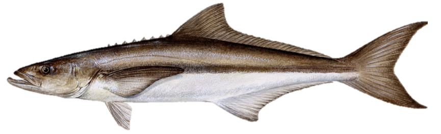
Cobia are the only member of their genus. Cobia are long and slim with a broad, flat head. The dorsal side of the fish is dark brown in color, while the ventral side is milky white. The lateral line is dark and obvious, and runs through the eye to the forked tail. Cobia have many small teeth in their mouths, and approximately eight short, unconnected spines between the head and dorsal fin. According to stock characteristics the maximum age is 11 years, the maximum weight is 68 kg (150 pounds) whole weight, and the maximum length is 198 cm (78 inches) total length.
Life History and Distribution
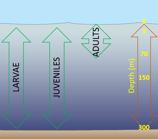
Cobia migrate seasonally, and can be found in the northern Gulf from March to October and in the southern Gulf and south Florida from November to March. In the Gulf, spawning occurs in coastal waters from April to September at temperatures ranging from 23-28 °C (73-82 °F). Cobia which are ready to spawn display a white horizontal stripe down each side of the body. Eggs are found in the top meter (3 ft) of the water column, drifting with the currents, and are estimated to hatch within 36 hours. From May to September, larvae are commonly found in surface waters, and occasionally at depths of up to 300 m (984 ft), where they likely feed on zooplankton. Larvae transition to coastal and offshore waters as juveniles after approximately 25 days, often guided by currents, feeding on small fishes, squid, and shrimp. Adult cobia are found in coastal and offshore waters in depths up to 70 m (230 ft). Adults feed on fishes and crustaceans, including crabs.
Gulf States Marine Fisheries Commission (GSMFC) Management Profile for Gulf of Mexico Cobia
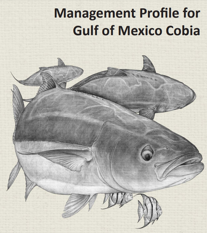
Cobia (Rachycentron canadum) is the only species within the family Rachycentridae and are found throughout most of the tropical and subtropical regions of the world’s oceans. Cobia supports both commercial and recreational fisheries but, in the U.S., recreational landings substantially exceed commercial landings. This species is managed as a federal fishery in the Gulf of Mexico by the Gulf of Mexico and South Atlantic Fishery Management Councils in the Coastal Migratory Pelagic (CMP) Fishery Management Plan. The current stock boundary separating the Atlantic and Gulf Cobia stocks was set between the jurisdictions of the GMFMC and SAFMC which was essentially the Florida Keys.
Download PDF here.
At the March 2017 Annual Spring Meeting of the Gulf States Marine Fisheries Commission, the State-Federal Fisheries Management Committee directed Commission staff to begin development of a Management Profile for Gulf of Mexico Cobia ahead of the anticipated stock assessment which was scheduled to begin in 2019. The Cobia Technical Task Force was established in the fall of 2017 and included representation from each of the state marine resource agencies and others as needed. The management profile was completed in late 2018 and made available in March of 2019 on the Commission’s webpage.