
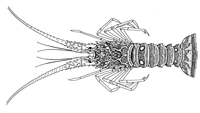
Scientific Name
Panulirus argus
Common Name
Rock lobster
Stock Status
Overfishing – No
Overfished – Unknown
Recreational Regulations
Federal Regulations
-
Open: January 01 – July 25
Closed: July 26 – August 05
Open: August 06 – March 31
Closed: April 01 – December 31
Open: January 01 – July 31
Closed: August 01 – December 31
- 6 Bag Limit
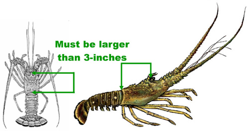
- Minimum Size: 3 in Carapace Length
Notes:
Divers must measure carapace while in water. Undersized lobster must be released unharmed immediately without removal from water.
Removal of tail at sea is prohibited without permit. No taking of berried (eggbearing) spiny lobster or slipper lobster.
No spears, hooks, or piercing devices. Explosives prohibited. For more information, see GulfCouncil.org
For info about lobster regulations off Florida, see Florida Spiny Lobster Regs.
To see commercial regulations, download Fish Rules Commercial App for iOS devices or Android devices.
Commercial Regulations
Spiny Lobster Tailing Permit – Gulf of Mexico EEZ and South Atlantic EEZ
-
Open year-round
- Minimum Size: 5.5 in Tail Length
- Maximum Size: None
Notes:
Timing & Permiting Requirements: Tailing is authorized only when the possession is incidental to fishing exclusively in the EEZ on a trip of 48 hours or more and a valid Federal tail-separation permit, AND either a valid Federal vessel permit for spiny lobster or a valid Florida Saltwater Products License with a valid Florida Restricted Species Endorsement and a valid Crawfish Endorsement.
Tail Length Requirements: If tailing, tail must be at least 5.5″. Divers must measure carapace while in water.
Condition Requirements: Fishermen with tailing permits must land spiny lobster all whole or all tailed.
Trip Limits & Size Limits: Trip Limits, Minimum Size Limits, and Gear Restrictions apply based on the other spiny lobster permits associated with the vessel. See the Spiny Lobster Federal Permit or the Spiny Lobster Florida EEZ Permits for additional information.
Berried Lobster: A berried (egg-bearing) spiny lobster in or from the EEZ must be returned immediately to the water unharmed.
Areas
Alabama Alps Reef
Alabama Alps Reef HAPC is bounded by rhumb lines connecting the following points in order: 29°16.160′ 88°20.525′ 29°15.427′ 88°18.990′ 29°13.380′ 88°19.051′ 29°14.140′ 88°20.533′ 29°16.160′ 88°20.525′Deployment of a bottom longline, bottom trawl, buoy gear, dredge, pot, or trap, and bottom anchoring by fishing vessels are prohibited year-round in the area of the HAPC.
West Flower Garden Banks
West Flower Garden Bank is bounded by rhumb lines connecting, in order, the following points: 27°55′22.8″ 93°53′09.6″; 27°55′22.8″ 93°46′46.0″; 27°49′03.0″ 93°46′46.0″; 27°49′03.0″ 93°53′09.6″; 27°55′22.8″ 93°53′09.6″.Deployment of bottom longline, bottom trawl, buoy gear, dredge, pot, or trap and bottom anchoring by fishing vessels is prohibited year-round.
West Florida Wall
West Florida Wall HAPC is bounded by rhumb lines connecting the following points in order: 26°28.835′ 84°47.955′; 26°28.816′ 84°46.754′; 26°10.471′ 84°42.076′; 26°10.528′ 84°44.577′; 26°25.028′ 84°47.986′; 26°25.100′ 84°47.980′; 26°28.835′ 84°47.955′.Deployment of bottom-tending gear (bottom longline, bottom trawl, buoy gear, dredge, pot or trap) and bottom anchoring by fishing vessels is prohibited year-round.
Viosca Knoll 862/906
Viosca Knoll 862/906 HAPC is bounded by rhumb lines connecting the following points in order: 29°07.640′ 88°23.608′; 29°07.603′ 88°20.590′; 29°03.749′ 88°20.554′; 29°03.734′ 88°22.016′; 29°02.367′ 88°21.998′; 29°02.281′ 88°24.972′; 29°07.568′ 88°25.044′; 29°07.592′ 88°25.044′; 29°07.676′ 88°25.045′; 29°07.640′ 88°23.608′.Deployment of a bottom longline, bottom trawl, buoy gear, dredge, pot, or trap, and bottom anchoring by fishing vessels are prohibited year-round in the area of the HAPC. This prohibition does not apply to a fishing vessel issued a Gulf royal red shrimp endorsement, as specified in §622.50(c), while the vessel is fishing for royal red shrimp.
Viosca Knoll 826
Viosca Knoll 826 HAPC is bounded by rhumb lines connecting the following points in order: 29°10.920′ 88°03.509′; 29°10.877′ 87°59.460′; 29°07.974′ 87°59.448′; 29°08.017′ 88°03.532′; 29°10.920′ 88°03.509′.Deployment of a bottom longline, bottom trawl, buoy gear, dredge, pot, or trap, and bottom anchoring by fishing vessels are prohibited year-round in the HAPC.
Tortugas South
Tortugas South area is bounded by rhumb lines connecting, in order, the following points: 24°33′00″ 83°09′00″; 24°33′00″ 83°05′00″; 24°18′00″ 83°05′00″; 24°18′00″ 83°09′00″; 24°33′00″ 83°09′00″.Fishing for any species and bottom anchoring by fishing vessels is prohibited year-round.
The Edges
The Edges is bounded by rhumb lines connecting, in order, the following points: 28°51′ 85°16′; 28°51′ 85°04′; 28°14′ 84°42′; 28°14′ 84°54′; 28°51′ 85°16′.All fishing prohibited January through April. Possession of any fish species is prohibited January through April, except when in transit with fishing gear stowed.
Stetson Bank
Stetson Bank HAPC is bounded by rhumb lines connecting, in order, the following points: 28°10′38.3″ 94°18′36.5″; 28°10′38.3″ 94°17′06.3″; 28°09′18.6″ 94°17′06.3″; 28°09′18.6″ 94°18′36.5″; 28°10′38.3″ 94°18′36.5″.Deployment of bottom longline, bottom trawl, buoy gear, pot, or trap and bottom anchoring by fishing vessels is prohibited year-round.
Steamboat Lumps
Steamboat Lumps is bounded by rhumb lines connecting, in order, the following points: 28°14′ 84°48′; 28°14′ 84°37′; 28°03′ 84°37′; 28°03′ 84°48′'; 28°14′ 84°48′.Possession of Reef Fish prohibited year-round, except when in transit with fishing gear stowed. Possession of all fish is prohibited November through April, except when in transit with fishing gear stowed. All Fishing Prohibited with the exception of surface trawling which is allowed May through October.
Southern Bank
Southern Bank HAPC is bounded by rhumb lines connecting the following points in order: 27°26.923′ 96°31.902′; 27°26.989′ 96°30.881′; 27°25.958′ 96°31.134′; 27°25.958′ 96°31.892′; 27°26.923′ 96°31.902′.Deployment of a bottom longline, bottom trawl, buoy gear, dredge, pot, or trap, and bottom anchoring by fishing vessels are prohibited year-round in the HAPC.
Roughtounge Reef
Roughtongue Reef HAPC is bounded by rhumb lines connecting the following points in order: 29°27.596′ 87°37.527′; 29°27.621′ 87°31.552′; 29°25.007′ 87°31.539′; 29°24.981′ 87°37.510′; 29°27.596′ 87°37.527′.Deployment of a bottom longline, bottom trawl, buoy gear, dredge, pot, or trap, and bottom anchoring by fishing vessels are prohibited year-round in the HAPC.
Pulley Ridge South Portion A
Pulley Ridge South Portion A HAPC is bounded by rhumb lines connecting the following points in order: 24°40.000′ 83°41.366′; 24°39.666′ 83°42.648′; 24°47.555′ 83°55.240′; 24°57.065′ 83°48.405′; 24°52.859′ 83°41.841′; 24°43.917′ 83°47.250′; 24°40.000′ 83°41.366′.Deployment of a bottom trawl, buoy gear, dredge, pot, or trap, and bottom anchoring by fishing vessels are prohibited year-round in the HAPC.
Pulley Ridge
Pulley Ridge HAPC is bounded by rhumb lines connecting the following points: A 24°58′18″ 83°38′33″; B 24°58′18″ 83°37′00″; C 24°41′11″ 83°37′00″; D 24°40′00″ 83°41′22″; E 24°43′55″ 83°47′15″; A 24°58′18″ 83°38′33″.Deployment of bottom longline, bottom trawl, buoy gear, pot, or trap and bottom anchoring by fishing vessels is prohibited year-round.
Mississippi Canyon 118
Mississippi Canyon 118 HAPC is bounded by rhumb lines connecting the following points in order: 28°53.183′ 88°30.789′; 28°53.216′ 88°27.819′; 28°50.602′88°27.782′; 28°48.944′ 88°27.759′; 28°48.962′ 88°30.727′; 28°53.183′ 88°30.789′.Deployment of a bottom longline, bottom trawl, buoy gear, dredge, pot, or trap, and bottom anchoring by fishing vessels are prohibited year-round in the HAPC.
McGrail Bank
McGrail Bank HAPC is bounded by rhumb lines connecting, in order, the following points: 27°59′06.0″ 92°37′19.2″; 27°59′06.0″ 92°32′17.4″; 27°55′55.5″ 92°32′17.4″; 27°55′55.5″ 92°37′19.2″; 27°59′06.0″ 92°37′19.2″.Deployment of bottom longline, bottom trawl, buoy gear, pot, or trap and bottom anchoring by fishing vessels is prohibited year-round.
Madison Swanson
The Madison and Swanson sites are bounded by rhumb lines connecting, in order, the following points: 29°17′ 85°50′; 29°17′ 85°38′; 29°06′ 85°38′; 29°06′ 85°50′; 29°17′ 85°50′.Fishing prohibited year-round. Possession of reef fish prohibited even for vessels in transit unless the vessel has an operating vessel monitoring system, a valid federal commercial Gulf of Mexico Reef Fish Permit, and fishing gear is appropriately stowed. These prohibitions do not apply to Atlantic Highly Migratory Species.
Lobster Trap Gear Closed Areas
Fishing with spiny lobster trap gear is prohibited year-round in the following areas bounded by rhumb lines connecting, in order, the points listed below:Lobster Trap Gear Closed Area 1: A 24°31′15.002″ 81°31′00.000", B 24°31′15.002″ 81°31′19.994"; C 24°31′29.999″ 81°31′19.994"; D 24°31′29.999″ 81°31′00.000"; A 24°31′15.002″ 81°31′00.000″.Lobster Trap Gear Closed Area 2: A 24°31′20.205″ 81°30′17.213"; B 24°31′17.858″ 81°30′27.700"; C 24°31′27.483″ 81°30′30.204"; D 24°31′29.831″ 81°30′19.483"; A 24°31′20.205″ 81°30′17.213″. Lobster Trap Gear Closed Area 3: A 24°31′42.665″ 81°30′02.892"; B 24°31′45.013″ 81°29′52.093"; C 24°31′34.996″ 81°29′49.745"; D 24°31′32.335″ 81°30′00.466"; A 24°31′42.665″ 81°30′02.892″. Lobster Trap Gear Closed Area 4: A 24°31′50.996″ 81°28′39.999"; B 24°31′50.996″ 81°29′03.002"; C 24°31′56.998″ 81°29′03.002"; D 24°31′56.998″ 81°28′39.999"; A 24°31′50.996″ 81°28′39.999″. Lobster Trap Gear Closed Area 5: A 24°32′20.014″ 81°26′20.390"; B 24°32′13.999″ 81°26′41.999"; C 24°32′27.004″ 81°26′45.611"; D 24°32′33.005″ 81°26′23.995"; A 24°32′20.014″ 81°26′20.390″.Lobster Trap Gear Closed Area 6: A 24°32′30.011″ 81°24′47.000"; B 24°32′23.790″ 81°24′56.558"; C 24°32′45.997″ 81°25′10.998"; D 24°32′52.218″ 81°25′01.433"; A 24°32′30.011″ 81°24′47.000″.Lobster Trap Gear Closed Area 7: A 24°32′46.834″ 81°27′17.615"; B 24°32′41.835″ 81°27′35.619"; C 24°32′54.003″ 81°27′38.997"; D 24°32′59.002″ 81°27′21.000"; A 24°32′46.834″ 81°27′17.615″.Lobster Trap Gear Closed Area 8: A 24°33′10.002″ 81°25′50.995"; B 24°33′04.000″ 81°26′18.996"; C 24°33′17.253″ 81°26′21.839"; D 24°33′23.254″ 81°25′53.838"; A 24°33′10.002″ 81°25′50.995″. Lobster Trap Gear Closed Area 9: A 24°33′22.004″ 81°30′31.998"; B 24°33′22.004″ 81°30′41.000"; C 24°33′29.008″ 81°30′41.000"; D 24°33′29.008″ 81°30′31.998"; A 24°33′22.004″ 81°30′31.998″.Lobster Trap Gear Closed Area 10: A 24°33′33.004″ 81°30′00.000"; B 24°33′33.004″ 81°30′09.998"; C 24°33′41.999″ 81°30′09.998"; D 24°33′41.999″ 81°30′00.000"; A 24°33′33.004″ 81°30′00.000″.Lobster Trap Gear Closed Area 11: A 24°33′50.376″ 81°23′35.039"; B 24°33′27.003″ 81°24′51.003"; C 24°33′40.008″ 81°24′54.999"; D 24°34′03.382″ 81°23′39.035"; A 24°33′50.376″ 81°23′35.039″.Lobster Trap Gear Closed Area 12: A 24°34′00.003″ 81°19′29.996"; B 24°34′00.003″ 81°20′04.994"; C 24°34′24.997″ 81°20′04.994"; D 24°34′24.997″ 81°19′29.996"; A 24°34′00.003″ 81°19′29.996″. Lobster Trap Gear Closed Area 13: A 24°35′19.997″ 81°14′25.002"; B 24°35′19.997″ 81°14′34.999"; C 24°35′29.006″ 81°14′34.999"; D 24°35′29.006″ 81°14′25.002"; A 24°35′19.997″ 81°14′25.002″.Lobster Trap Gear Closed Area 14: A 24°44′37.004″ 80°46′47.000"; B 24°44′37.004″ 80°46′58.000"; C 24°44′47.002″ 80°46′58.000"; D 24°44′47.002″ 80°46′47.000"; A 24°44′37.004″ 80°46′47.000″. Lobster Trap Gear Closed Area 15: A 24°49′53.946″ 80°38′17.646"; B 24°48′32.331″ 80°40′15.530"; C 24°48′44.389″ 80°40′23.879"; D 24°50′06.004″ 80°38′26.003"; A 24°49′53.946″ 80°38′17.646″. Lobster Trap Gear Closed Area 16: A 24°53′32.085″ 80°33′22.065"; B 24°53′38.992″ 80°33′14.670"; C 24°53′31.673″ 80°33′07.155"; D 24°53′24.562″ 80°33′14.886"; A 24°53′32.085″ 80°33′22.065″.Lobster Trap Gear Closed Area 17: A 24°53′33.410″ 80°32′50.247"; B 24°53′40.149″ 80°32′42.309"; C 24°53′32.418″ 80°32′35.653"; D 24°53′25.348″ 80°32′43.302"; A 24°53′33.410″ 80°32′50.247″.Lobster Trap Gear Closed Area 18: A 24°54′06.317″ 80°32′34.115"; B 24°53′59.368″ 80°32′41.542"; C 24°54′06.667″ 80°32′48.994"; D 24°54′13.917″ 80°32′41.238"; A 24°54′06.317″ 80°32′34.115″.Lobster Trap Gear Closed Area 19: A 24°54′06.000″ 80°31′33.995"; B 24°54′06.000″ 80°31′45.002"; C 24°54′36.006″ 80°31′45.002"; D 24°54′36.006″ 80°31′33.995"; A 24°54′06.000″ 80°31′33.995″.Lobster Trap Gear Closed Area 20: A 24°56′21.104″ 80°28′52.331"; B 24°56′17.012″ 80°29′05.995"; C 24°56′26.996″ 80°29′08.996"; D 24°56′31.102″ 80°28′55.325"; A 24°56′21.104″ 80°28′52.331″.Lobster Trap Gear Closed Area 21: A 24°56′53.006″ 80°27′46.997"; B 24°56′21.887″ 80°28′25.367"; C 24°56′35.002″ 80°28′36.003"; D 24°57′06.107″ 80°27′57.626"; A 24°56′53.006″ 80°27′46.997″. Lobster Trap Gear Closed Area 22: A 24°57′35.001″ 80°27′14.999"; B 24°57′28.011″ 80°27′21.000"; C 24°57′33.999″ 80°27′27.997"; D 24°57′40.200″ 80°27′21.106"; A 24°57′35.001″ 80°27′14.999″.Lobster Trap Gear Closed Area 23: A 24°58′58.154″ 80°26′03.911"; B 24°58′48.005″ 80°26′10.001"; C 24°58′52.853″ 80°26′18.090"; D 24°59′03.002″ 80°26′11.999"; A 24°58′58.154″ 80°26′03.911″.Lobster Trap Gear Closed Area 24: A 24°59′17.009″ 80°24′32.999"; B 24°58′41.001″ 80°25′21.998"; C 24°58′57.591″ 80°25′34.186"; D 24°59′33.598″ 80°24′45.187"; A 24°59′17.009″ 80°24′32.999″.Lobster Trap Gear Closed Area 25: A 24°59′44.008″ 80°25′38.999"; B 24°59′27.007″ 80°25′48.997"; C 24°59′32.665″ 80°25′58.610"; D 24°59′49.666″ 80°25′48.612"; A 24°59′44.008″ 80°25′38.999″.Lobster Trap Gear Closed Area 26: A 25°01′00.006″ 80°21′55.002"; B 25°01′00.006″ 80°22′11.996"; C 25°01′18.010″ 80°22′11.996"; D 25°01′18.010″ 80°21′55.002"; A 25°01′00.006″ 80°21′55.002″.Lobster Trap Gear Closed Area 27: A 25°01′34.997″ 80°23′12.998"; B 25°01′18.010″ 80°23′44.000"; C 25°01′22.493″ 80°23′46.473"; D 25°01′36.713″ 80°23′37.665"; E 25°01′46.657″ 80°23′19.390"; A 25°01′34.997″ 80°23′12.998″.Lobster Trap Gear Closed Area 28: A 25°01′38.005″ 80°21′25.998"; B 25°01′28.461″ 80°21′46.158"; C 25°01′45.009″ 80°21′53.999"; D 25°01′54.553″ 80°21′33.839"; A 25°01′38.005″ 80°21′25.998″.Lobster Trap Gear Closed Area 29: A 25°01′53.001″ 80°23′08.995"; B 25°01′53.001″ 80°23′17.997"; C 25°02′01.008″ 80°23′17.997"; D 25°02′01.008″ 80°23′08.995"; A 25°01′53.001″ 80°23′08.995″.Lobster Trap Gear Closed Area 30: A 25°02′20.000″ 80°22′11.001"; B 25°02′10.003″ 80°22′50.002"; C 25°02′22.252″ 80°22′53.140"; D 25°02′32.250″ 80°22′14.138"; A 25°02′20.000″ 80°22′11.001″.Lobster Trap Gear Closed Area 31: A 25°02′29.503″ 80°20′30.503"; B 25°02′16.498″ 80°20′43.501"; C 25°02′24.999″ 80°20′52.002"; D 25°02′38.004″ 80°20′38.997"; A 25°02′29.503″ 80°20′30.503″. Lobster Trap Gear Closed Area 32: A 25°02′34.008″ 80°21′57.000"; B 25°02′34.008″ 80°22′14.997"; C 25°02′50.007″ 80°22′14.997"; D 25°02′50.007″ 80°21′57.000"; A 25°02′34.008″ 80°21′57.000″.Lobster Trap Gear Closed Area 33: A 25°03′11.294″ 80°21′36.864"; B 25°03′02.540″ 80°21′43.143"; C 25°03′08.999″ 80°21′51.994"; D 25°03′17.446″ 80°21′45.554"; A 25°03′11.294″ 80°21′36.864″.Lobster Trap Gear Closed Area 34: A 25°03′30.196″ 80°21′34.263"; B 25°03′39.267″ 80°21′29.506"; C 25°03′35.334″ 80°21′19.801"; D 25°03′26.200″ 80°21′24.304"; A 25°03′30.196″ 80°21′34.263″.Lobster Trap Gear Closed Area 35: A 25°03′26.001″ 80°19′43.001"; B 25°03′26.001″ 80°19′54.997"; C 25°03′41.011″ 80°19′54.997"; D 25°03′41.011″ 80°19′43.001"; A 25°03′26.001″ 80°19′43.001″.Lobster Trap Gear Closed Area 36: A 25°07′03.008″ 80°17′57.999"; B 25°07′03.008″ 80°18′10.002"; C 25°07′14.997″ 80°18′10.002"; D 25°07′14.997″ 80°17′57.999"; A 25°07′03.008″ 80°17′57.999″.Lobster Trap Gear Closed Area 37: A 25°07′51.156″ 80°17′27.910"; B 25°07′35.857″ 80°17′37.091"; C 25°07′43.712″ 80°17′50.171"; D 25°07′59.011″ 80°17′40.998"; A 25°07′51.156″ 80°17′27.910″.Lobster Trap Gear Closed Area 38: A 25°08′12.002″ 80°17′09.996"; B 25°07′55.001″ 80°17′26.997"; C 25°08′04.998″ 80°17′36.995"; D 25°08′22.000″ 80°17′20.000"; A 25°08′12.002″ 80°17′09.996″.Lobster Trap Gear Closed Area 39: A 25°08′18.003″ 80°17′34.001"; B 25°08′18.003″ 80°17′45.997"; C 25°08′29.003″ 80°17′45.997"; D 25°08′29.003″ 80°17′34.001"; A 25°08′18.003″ 80°17′34.001″.Lobster Trap Gear Closed Area 40: A 25°08′45.002″ 80°15′50.002"; B 25°08′37.999″ 80°15′56.998"; C 25°08′42.009″ 80°16′00.995"; D 25°08′48.999″ 80°15′53.998"; A 25°08′45.002″ 80°15′50.002".Lobster Trap Gear Closed Area 41: A 25°08′58.007″ 80°17′24.999"; B 25°08′58.007″ 80°17′35.999"; C 25°09′09.007″ 80°17′35.999"; D 25°09′09.007″ 80°17′24.999"; A 25°08′58.007″ 80°17′24.999".Lobster Trap Gear Closed Area 42: A 25°09′10.999″ 80°16′00.000"; B 25°09′10.999″ 80°16′09.997"; C 25°09′20.996″ 80°16′09.997"; D 25°09′20.996″ 80°16′00.000"; A 25°09′10.999″ 80°16′00.000".Lobster Trap Gear Closed Area 43: A 25°09′28.316″ 80°17′03.713"; B 25°09′14.006″ 80°17′17.000"; C 25°09′21.697″ 80°17′25.280"; D 25°09′36.006″ 80°17′12.001"; A 25°09′28.316″ 80°17′03.713".Lobster Trap Gear Closed Area 44: A 25°10′00.011″ 80°16′06.000"; B 25°10′00.011″ 80°16′17.000"; C 25°10′09.995″ 80°16′17.000"; D 25°10′09.995″ 80°16′06.000"; A 25°10′00.011″ 80°16′06.000".Lobster Trap Gear Closed Area 45: A 25°10′29.002″ 80°15′52.995"; B 25°10′29.002″ 80°16′04.002"; C 25°10′37.997″ 80°16′04.002"; D 25°10′37.997″ 80°15′52.995"; A 25°10′29.002″ 80°15′52.995".Lobster Trap Gear Closed Area 46: A 25°11′05.998″ 80°14′25.997"; B 25°11′05.998″ 80°14′38.000"; C 25°11′20.006″ 80°14′38.000"; D 25°11′20.006″ 80°14′25.997"; A 25°11′05.998″ 80°14′25.997".Lobster Trap Gear Closed Area 47: A 25°12′00.998″ 80°13′24.996"; B 25°11′43.008″ 80°13′35.000"; C 25°11′48.007″ 80°13′44.002"; D 25°12′06.011″ 80°13′33.998"; A 25°12′00.998″ 80°13′24.996".Lobster Trap Gear Closed Area 48: A 25°12′18.343″ 80°14′32.768"; B 25°12′02.001″ 80°14′44.001"; C 25°12′07.659″ 80°14′52.234"; D 25°12′24.001″ 80°14′41.001"; A 25°12′18.343″ 80°14′32.768".Lobster Trap Gear Closed Area 49: A 25°15′23.998″ 80°12′29.000"; B 25°15′04.676″ 80°12′36.120"; C 25°15′09.812″ 80°12′50.066"; D 25°15′29.148″ 80°12′42.946"; A 25°15′23.998″ 80°12′29.000".Lobster Trap Gear Closed Area 50. A 25°16′01.997″ 80°12′32.996"; B 25°15′33.419″ 80°12′52.394"; C 25°15′44.007″ 80°13′08.001"; D 25°16′12.585″ 80°12′48.597"; A 25°16′01.997″ 80°12′32.996".Lobster Trap Gear Closed Area 51: A 25°16′33.006″ 80°13′30.001"; B 25°16′33.006″ 80°13′41.001"; C 25°16′34.425″ 80°13′41.026"; D 25°16′41.850″ 80°13′37.475"; E 25°16′42.001″ 80°13′30.001"; A 25°16′33.006″ 80°13′30.001".Lobster Trap Gear Closed Area 52: A 25°17′04.715″ 80°12′11.305"; B 25°16′17.007″ 80°12′27.997"; C 25°16′23.997″ 80°12′47.999"; D 25°17′11.705″ 80°12′31.300"; A 25°17′04.715″ 80°12′11.305".Lobster Trap Gear Closed Area 53: A 25°17′23.008″ 80°12′40.000"; B 25°17′23.008″ 80°12′49.997"; C 25°17′33.005″ 80°12′49.997"; D 25°17′33.005″ 80°12′40.000"; A 25°17′23.008″ 80°12′40.000".Lobster Trap Gear Closed Area 54: A 25°20′57.996″ 80°09′50.000"; B 25°20′57.996″ 80°10′00.000"; C 25°21′07.005″ 80°10′00.000"; D 25°21′07.005″ 80°09′50.000"; A 25°20′57.996″ 80°09′50.000". Lobster Trap Gear Closed Area 55: A 25°21′45.004″ 80°09′51.998"; B 25°21′38.124″ 80°09′56.722"; C 25°21′49.124″ 80°10′12.728"; D 25°21′56.004″ 80°10′07.997"; A 25°21′45.004″ 80°09′51.998".Lobster Trap Gear Closed Area 56: A 25°21′49.000″ 80°09′21.999"; B 25°21′49.000″ 80°09′31.996"; C 25°21′58.998″ 80°09′31.996"; D 25°21′58.998″ 80°09′21.999"; A 25°21′49.000″ 80°09′21.999".Lobster Trap Gear Closed Area 57: A 25°24′31.008″ 80°07′36.997"; B 25°24′31.008″ 80°07′48.999"; C 25°24′41.005″ 80°07′48.999"; D 25°24′41.005″ 80°07′36.997"; A 25°24′31.008″ 80°07′36.997".Lobster Trap Gear Closed Area 58: A 25°25′14.005″ 80°07′27.995"; B 25°25′14.005″ 80°07′44.001"; C 25°25′26.008″ 80°07′44.001"; D 25°25′26.008″ 80°07′27.995"; A 25°25′14.005″ 80°07′27.995".Lobster Trap Gear Closed Area 59: A 25°35′13.996″ 80°05′39.999"; B 25°35′13.996″ 80°05′50.999"; C 25°35′24.007″ 80°05′50.999"; D 25°35′24.007″ 80°05′39.999"; A 25°35′13.996″ 80°05′39.999". Lobster Trap Gear Closed Area 60: A 25°40′57.003″, 80°05′43.000″; B 25°40′57.003″, 80°05′54.000″; C 25°41′06.550″, 80°05′53.980″; D 25°41′18.136″, 80°05′49.158″; E 25°41′18.001″, 80°05′43.000″; A 25°40′57.003″, 80°05′43.000″.
L&W Pinnacles and Scamp Reef
L & W Pinnacles and Scamp Reef HAPC is bounded by rhumb lines connecting the following points in order: 29°18.595′ 87°48.757′; 29°18.484′ 87°50.688′; 29°19.754′ 87°52.484′; 29°20.401′ 87°51.449′; 29°20.095′ 87°50.933′; 29°20.832′ 87°46.631′; 29°21.473′ 87°46.326′; 29°21.314′ 87°45.535′; 29°22.518′ 87°43.465′; 29°21.144′ 87°42.632′; 29°19.269′ 87°45.525′; 29°18.595′ 87°48.757′.Deployment of a bottom longline, bottom trawl, buoy gear, dredge, pot, or trap, and bottom anchoring by fishing vessels are prohibited year-round in the area of the HAPC.
Harte Bank
Harte Bank HAPC is bounded by rhumb lines connecting the following points in order: 26°40.826′ 96°36.590′; 26°40.789′ 96°32.220′; 26°37.992′ 96°32.308′; 26°38.043′ 96°36.636′; 26°40.826′ 96°36.590′.Deployment of a bottom longline, bottom trawl, buoy gear, dredge, pot, or trap, and bottom anchoring by fishing vessels are prohibited year-round in the HAPC.
Green Canyon 852
Green Canyon 852 HAPC is bounded by rhumb lines connecting the following points in order: 27°08.354′ 91°08.929′; 27°05.740′ 91°08.963′; 27°05.762′ 91°10.610′; 27°08.376′ 91°10.567′; 27°08.354′ 91°08.929′.Deployment of a bottom longline, bottom trawl, buoy gear, dredge, pot, or trap, and bottom anchoring by fishing vessels are prohibited year-round in the HAPC.
Florida Middle Grounds
Florida Middle Grounds HAPC is the area bounded by rhumb lines connecting the following points: 28°42.5′ N 84°24.8′ W28°42.5′ N 84°16.3′ W28°11.0′ N 84°00.0′ W28°11.0′ N 84°07.0′ W28°26.6′ N 84°24.8′ W28°42.5′ N 84°24.8′ WDeployment of bottom longline, bottom trawl, dredge, pot, or trap is prohibited year-round.
EEZ Tortugas North
The area is bounded by rhumb lines connecting the following points: From point A at 24°40′00″ N. lat., 83°06′00″ W. long. to point B at 24°46′00″ N. lat., 83°06′00″ W. long. to point C at 24°46′00″ N. lat., 83°00′00″ W. long.; thence along the line denoting the seaward limit of Florida's waters, as shown on the current edition of NOAA chart 11434, to point A at 24°40′00″ N. lat., 83°06′00″ W. long.Fishing for any species and bottom anchoring by fishing vessels is prohibited year-round.
East Flower Garden Banks
East Flower Garden Bank is bounded by rhumb lines connecting, in order, the following points: 27°59′14.4″ N 93°38′58.2″ W27°59′14.4″ N 93°34′03.5″ W27°52′36.5″ N 93°34′03.5″ W27°52′36.5″ N 93°38′58.2″ W27°59′14.4″ N 93°38′58.2″ WDeployment of bottom longline, bottom trawl, buoy gear, dredge, pot, or trap and bottom anchoring by fishing vessels is prohibited year-round.
AT 357
AT 357 HAPC is bounded by rhumb lines connecting the following points in order: 27°36.259' N 89°43.068' W 27°36.315' N 89°40.136' W27°33.703' N 89°40.073' W27°33.646' N 89°43.004' WDeployment of a bottom longline, bottom trawl, buoy gear, dredge, pot, or trap, and bottom anchoring by fishing vessels are prohibited year-round in the HAPC.
AT 047
AT 047 HAPC is bounded by rhumb lines connecting the following points in order: 27°54.426′ N 89°49.404′ W27°54.486′ N 89°46.464′ W27°51.874′ N 89°46.397′ W27°51.814′ N 89°49.336′ WDeployment of a bottom longline, bottom trawl, buoy gear, dredge, pot, or trap and bottom anchoring by fishing vessels are prohibited year-round in the HAPC.
Conditions
Harvest Limitations
Tailing is authorized only when the possession is incidental to fishing exclusively in the EEZ on a trip of 48 hours or more and a valid Federal tail-separation permit, AND either a valid Federal vessel permit for spiny lobster or a valid Florida Saltwater Products License with a valid Florida Restricted Species Endorsement and a valid Crawfish Endorsement.
Sale Purchase Restrictions
Spiny lobster harvested in or from the Gulf or South Atlantic EEZ or adjoining state waters by a vessel that has a commercial Spiny Lobster Permit may be sold or transferred only to a dealer who has a valid Gulf and South Atlantic dealer permit.
Spiny Lobster Federal Permit – South Atlantic EEZ (not including Florida)
-
Fishing year begins Jan 1
Open year-round
- Minimum Size: 3 in Carapace Length
- Maximum Size: None
- 2 qty Lobster Trip Limit
Notes:
Undersized Lobster: Undersized lobster must be released unharmed immediately without removal from water.
Berried Lobster: A berried (egg-bearing) spiny lobster in or from the EEZ must be returned immediately to the water unharmed.
Areas
Alabama Alps Reef
Alabama Alps Reef HAPC is bounded by rhumb lines connecting the following points in order: 29°16.160′ 88°20.525′ 29°15.427′ 88°18.990′ 29°13.380′ 88°19.051′ 29°14.140′ 88°20.533′ 29°16.160′ 88°20.525′Deployment of a bottom longline, bottom trawl, buoy gear, dredge, pot, or trap, and bottom anchoring by fishing vessels are prohibited year-round in the area of the HAPC.
West Flower Garden Banks
West Flower Garden Bank is bounded by rhumb lines connecting, in order, the following points: 27°55′22.8″ 93°53′09.6″; 27°55′22.8″ 93°46′46.0″; 27°49′03.0″ 93°46′46.0″; 27°49′03.0″ 93°53′09.6″; 27°55′22.8″ 93°53′09.6″.Deployment of bottom longline, bottom trawl, buoy gear, dredge, pot, or trap and bottom anchoring by fishing vessels is prohibited year-round.
West Florida Wall
West Florida Wall HAPC is bounded by rhumb lines connecting the following points in order: 26°28.835′ 84°47.955′; 26°28.816′ 84°46.754′; 26°10.471′ 84°42.076′; 26°10.528′ 84°44.577′; 26°25.028′ 84°47.986′; 26°25.100′ 84°47.980′; 26°28.835′ 84°47.955′.Deployment of bottom-tending gear (bottom longline, bottom trawl, buoy gear, dredge, pot or trap) and bottom anchoring by fishing vessels is prohibited year-round.
Viosca Knoll 862/906
Viosca Knoll 862/906 HAPC is bounded by rhumb lines connecting the following points in order: 29°07.640′ 88°23.608′; 29°07.603′ 88°20.590′; 29°03.749′ 88°20.554′; 29°03.734′ 88°22.016′; 29°02.367′ 88°21.998′; 29°02.281′ 88°24.972′; 29°07.568′ 88°25.044′; 29°07.592′ 88°25.044′; 29°07.676′ 88°25.045′; 29°07.640′ 88°23.608′.Deployment of a bottom longline, bottom trawl, buoy gear, dredge, pot, or trap, and bottom anchoring by fishing vessels are prohibited year-round in the area of the HAPC. This prohibition does not apply to a fishing vessel issued a Gulf royal red shrimp endorsement, as specified in §622.50(c), while the vessel is fishing for royal red shrimp.
Viosca Knoll 826
Viosca Knoll 826 HAPC is bounded by rhumb lines connecting the following points in order: 29°10.920′ 88°03.509′; 29°10.877′ 87°59.460′; 29°07.974′ 87°59.448′; 29°08.017′ 88°03.532′; 29°10.920′ 88°03.509′.Deployment of a bottom longline, bottom trawl, buoy gear, dredge, pot, or trap, and bottom anchoring by fishing vessels are prohibited year-round in the HAPC.
Tortugas South
Tortugas South area is bounded by rhumb lines connecting, in order, the following points: 24°33′00″ 83°09′00″; 24°33′00″ 83°05′00″; 24°18′00″ 83°05′00″; 24°18′00″ 83°09′00″; 24°33′00″ 83°09′00″.Fishing for any species and bottom anchoring by fishing vessels is prohibited year-round.
The Edges
The Edges is bounded by rhumb lines connecting, in order, the following points: 28°51′ 85°16′; 28°51′ 85°04′; 28°14′ 84°42′; 28°14′ 84°54′; 28°51′ 85°16′.All fishing prohibited January through April. Possession of any fish species is prohibited January through April, except when in transit with fishing gear stowed.
Stetson Bank
Stetson Bank HAPC is bounded by rhumb lines connecting, in order, the following points: 28°10′38.3″ 94°18′36.5″; 28°10′38.3″ 94°17′06.3″; 28°09′18.6″ 94°17′06.3″; 28°09′18.6″ 94°18′36.5″; 28°10′38.3″ 94°18′36.5″.Deployment of bottom longline, bottom trawl, buoy gear, pot, or trap and bottom anchoring by fishing vessels is prohibited year-round.
Steamboat Lumps
Steamboat Lumps is bounded by rhumb lines connecting, in order, the following points: 28°14′ 84°48′; 28°14′ 84°37′; 28°03′ 84°37′; 28°03′ 84°48′'; 28°14′ 84°48′.Possession of Reef Fish prohibited year-round, except when in transit with fishing gear stowed. Possession of all fish is prohibited November through April, except when in transit with fishing gear stowed. All Fishing Prohibited with the exception of surface trawling which is allowed May through October.
Southern Bank
Southern Bank HAPC is bounded by rhumb lines connecting the following points in order: 27°26.923′ 96°31.902′; 27°26.989′ 96°30.881′; 27°25.958′ 96°31.134′; 27°25.958′ 96°31.892′; 27°26.923′ 96°31.902′.Deployment of a bottom longline, bottom trawl, buoy gear, dredge, pot, or trap, and bottom anchoring by fishing vessels are prohibited year-round in the HAPC.
Roughtounge Reef
Roughtongue Reef HAPC is bounded by rhumb lines connecting the following points in order: 29°27.596′ 87°37.527′; 29°27.621′ 87°31.552′; 29°25.007′ 87°31.539′; 29°24.981′ 87°37.510′; 29°27.596′ 87°37.527′.Deployment of a bottom longline, bottom trawl, buoy gear, dredge, pot, or trap, and bottom anchoring by fishing vessels are prohibited year-round in the HAPC.
Pulley Ridge South Portion A
Pulley Ridge South Portion A HAPC is bounded by rhumb lines connecting the following points in order: 24°40.000′ 83°41.366′; 24°39.666′ 83°42.648′; 24°47.555′ 83°55.240′; 24°57.065′ 83°48.405′; 24°52.859′ 83°41.841′; 24°43.917′ 83°47.250′; 24°40.000′ 83°41.366′.Deployment of a bottom trawl, buoy gear, dredge, pot, or trap, and bottom anchoring by fishing vessels are prohibited year-round in the HAPC.
Pulley Ridge
Pulley Ridge HAPC is bounded by rhumb lines connecting the following points: A 24°58′18″ 83°38′33″; B 24°58′18″ 83°37′00″; C 24°41′11″ 83°37′00″; D 24°40′00″ 83°41′22″; E 24°43′55″ 83°47′15″; A 24°58′18″ 83°38′33″.Deployment of bottom longline, bottom trawl, buoy gear, pot, or trap and bottom anchoring by fishing vessels is prohibited year-round.
Mississippi Canyon 118
Mississippi Canyon 118 HAPC is bounded by rhumb lines connecting the following points in order: 28°53.183′ 88°30.789′; 28°53.216′ 88°27.819′; 28°50.602′88°27.782′; 28°48.944′ 88°27.759′; 28°48.962′ 88°30.727′; 28°53.183′ 88°30.789′.Deployment of a bottom longline, bottom trawl, buoy gear, dredge, pot, or trap, and bottom anchoring by fishing vessels are prohibited year-round in the HAPC.
McGrail Bank
McGrail Bank HAPC is bounded by rhumb lines connecting, in order, the following points: 27°59′06.0″ 92°37′19.2″; 27°59′06.0″ 92°32′17.4″; 27°55′55.5″ 92°32′17.4″; 27°55′55.5″ 92°37′19.2″; 27°59′06.0″ 92°37′19.2″.Deployment of bottom longline, bottom trawl, buoy gear, pot, or trap and bottom anchoring by fishing vessels is prohibited year-round.
Madison Swanson
The Madison and Swanson sites are bounded by rhumb lines connecting, in order, the following points: 29°17′ 85°50′; 29°17′ 85°38′; 29°06′ 85°38′; 29°06′ 85°50′; 29°17′ 85°50′.Fishing prohibited year-round. Possession of reef fish prohibited even for vessels in transit unless the vessel has an operating vessel monitoring system, a valid federal commercial Gulf of Mexico Reef Fish Permit, and fishing gear is appropriately stowed. These prohibitions do not apply to Atlantic Highly Migratory Species.
Lobster Trap Gear Closed Areas
Fishing with spiny lobster trap gear is prohibited year-round in the following areas bounded by rhumb lines connecting, in order, the points listed below:Lobster Trap Gear Closed Area 1: A 24°31′15.002″ 81°31′00.000", B 24°31′15.002″ 81°31′19.994"; C 24°31′29.999″ 81°31′19.994"; D 24°31′29.999″ 81°31′00.000"; A 24°31′15.002″ 81°31′00.000″.Lobster Trap Gear Closed Area 2: A 24°31′20.205″ 81°30′17.213"; B 24°31′17.858″ 81°30′27.700"; C 24°31′27.483″ 81°30′30.204"; D 24°31′29.831″ 81°30′19.483"; A 24°31′20.205″ 81°30′17.213″. Lobster Trap Gear Closed Area 3: A 24°31′42.665″ 81°30′02.892"; B 24°31′45.013″ 81°29′52.093"; C 24°31′34.996″ 81°29′49.745"; D 24°31′32.335″ 81°30′00.466"; A 24°31′42.665″ 81°30′02.892″. Lobster Trap Gear Closed Area 4: A 24°31′50.996″ 81°28′39.999"; B 24°31′50.996″ 81°29′03.002"; C 24°31′56.998″ 81°29′03.002"; D 24°31′56.998″ 81°28′39.999"; A 24°31′50.996″ 81°28′39.999″. Lobster Trap Gear Closed Area 5: A 24°32′20.014″ 81°26′20.390"; B 24°32′13.999″ 81°26′41.999"; C 24°32′27.004″ 81°26′45.611"; D 24°32′33.005″ 81°26′23.995"; A 24°32′20.014″ 81°26′20.390″.Lobster Trap Gear Closed Area 6: A 24°32′30.011″ 81°24′47.000"; B 24°32′23.790″ 81°24′56.558"; C 24°32′45.997″ 81°25′10.998"; D 24°32′52.218″ 81°25′01.433"; A 24°32′30.011″ 81°24′47.000″.Lobster Trap Gear Closed Area 7: A 24°32′46.834″ 81°27′17.615"; B 24°32′41.835″ 81°27′35.619"; C 24°32′54.003″ 81°27′38.997"; D 24°32′59.002″ 81°27′21.000"; A 24°32′46.834″ 81°27′17.615″.Lobster Trap Gear Closed Area 8: A 24°33′10.002″ 81°25′50.995"; B 24°33′04.000″ 81°26′18.996"; C 24°33′17.253″ 81°26′21.839"; D 24°33′23.254″ 81°25′53.838"; A 24°33′10.002″ 81°25′50.995″. Lobster Trap Gear Closed Area 9: A 24°33′22.004″ 81°30′31.998"; B 24°33′22.004″ 81°30′41.000"; C 24°33′29.008″ 81°30′41.000"; D 24°33′29.008″ 81°30′31.998"; A 24°33′22.004″ 81°30′31.998″.Lobster Trap Gear Closed Area 10: A 24°33′33.004″ 81°30′00.000"; B 24°33′33.004″ 81°30′09.998"; C 24°33′41.999″ 81°30′09.998"; D 24°33′41.999″ 81°30′00.000"; A 24°33′33.004″ 81°30′00.000″.Lobster Trap Gear Closed Area 11: A 24°33′50.376″ 81°23′35.039"; B 24°33′27.003″ 81°24′51.003"; C 24°33′40.008″ 81°24′54.999"; D 24°34′03.382″ 81°23′39.035"; A 24°33′50.376″ 81°23′35.039″.Lobster Trap Gear Closed Area 12: A 24°34′00.003″ 81°19′29.996"; B 24°34′00.003″ 81°20′04.994"; C 24°34′24.997″ 81°20′04.994"; D 24°34′24.997″ 81°19′29.996"; A 24°34′00.003″ 81°19′29.996″. Lobster Trap Gear Closed Area 13: A 24°35′19.997″ 81°14′25.002"; B 24°35′19.997″ 81°14′34.999"; C 24°35′29.006″ 81°14′34.999"; D 24°35′29.006″ 81°14′25.002"; A 24°35′19.997″ 81°14′25.002″.Lobster Trap Gear Closed Area 14: A 24°44′37.004″ 80°46′47.000"; B 24°44′37.004″ 80°46′58.000"; C 24°44′47.002″ 80°46′58.000"; D 24°44′47.002″ 80°46′47.000"; A 24°44′37.004″ 80°46′47.000″. Lobster Trap Gear Closed Area 15: A 24°49′53.946″ 80°38′17.646"; B 24°48′32.331″ 80°40′15.530"; C 24°48′44.389″ 80°40′23.879"; D 24°50′06.004″ 80°38′26.003"; A 24°49′53.946″ 80°38′17.646″. Lobster Trap Gear Closed Area 16: A 24°53′32.085″ 80°33′22.065"; B 24°53′38.992″ 80°33′14.670"; C 24°53′31.673″ 80°33′07.155"; D 24°53′24.562″ 80°33′14.886"; A 24°53′32.085″ 80°33′22.065″.Lobster Trap Gear Closed Area 17: A 24°53′33.410″ 80°32′50.247"; B 24°53′40.149″ 80°32′42.309"; C 24°53′32.418″ 80°32′35.653"; D 24°53′25.348″ 80°32′43.302"; A 24°53′33.410″ 80°32′50.247″.Lobster Trap Gear Closed Area 18: A 24°54′06.317″ 80°32′34.115"; B 24°53′59.368″ 80°32′41.542"; C 24°54′06.667″ 80°32′48.994"; D 24°54′13.917″ 80°32′41.238"; A 24°54′06.317″ 80°32′34.115″.Lobster Trap Gear Closed Area 19: A 24°54′06.000″ 80°31′33.995"; B 24°54′06.000″ 80°31′45.002"; C 24°54′36.006″ 80°31′45.002"; D 24°54′36.006″ 80°31′33.995"; A 24°54′06.000″ 80°31′33.995″.Lobster Trap Gear Closed Area 20: A 24°56′21.104″ 80°28′52.331"; B 24°56′17.012″ 80°29′05.995"; C 24°56′26.996″ 80°29′08.996"; D 24°56′31.102″ 80°28′55.325"; A 24°56′21.104″ 80°28′52.331″.Lobster Trap Gear Closed Area 21: A 24°56′53.006″ 80°27′46.997"; B 24°56′21.887″ 80°28′25.367"; C 24°56′35.002″ 80°28′36.003"; D 24°57′06.107″ 80°27′57.626"; A 24°56′53.006″ 80°27′46.997″. Lobster Trap Gear Closed Area 22: A 24°57′35.001″ 80°27′14.999"; B 24°57′28.011″ 80°27′21.000"; C 24°57′33.999″ 80°27′27.997"; D 24°57′40.200″ 80°27′21.106"; A 24°57′35.001″ 80°27′14.999″.Lobster Trap Gear Closed Area 23: A 24°58′58.154″ 80°26′03.911"; B 24°58′48.005″ 80°26′10.001"; C 24°58′52.853″ 80°26′18.090"; D 24°59′03.002″ 80°26′11.999"; A 24°58′58.154″ 80°26′03.911″.Lobster Trap Gear Closed Area 24: A 24°59′17.009″ 80°24′32.999"; B 24°58′41.001″ 80°25′21.998"; C 24°58′57.591″ 80°25′34.186"; D 24°59′33.598″ 80°24′45.187"; A 24°59′17.009″ 80°24′32.999″.Lobster Trap Gear Closed Area 25: A 24°59′44.008″ 80°25′38.999"; B 24°59′27.007″ 80°25′48.997"; C 24°59′32.665″ 80°25′58.610"; D 24°59′49.666″ 80°25′48.612"; A 24°59′44.008″ 80°25′38.999″.Lobster Trap Gear Closed Area 26: A 25°01′00.006″ 80°21′55.002"; B 25°01′00.006″ 80°22′11.996"; C 25°01′18.010″ 80°22′11.996"; D 25°01′18.010″ 80°21′55.002"; A 25°01′00.006″ 80°21′55.002″.Lobster Trap Gear Closed Area 27: A 25°01′34.997″ 80°23′12.998"; B 25°01′18.010″ 80°23′44.000"; C 25°01′22.493″ 80°23′46.473"; D 25°01′36.713″ 80°23′37.665"; E 25°01′46.657″ 80°23′19.390"; A 25°01′34.997″ 80°23′12.998″.Lobster Trap Gear Closed Area 28: A 25°01′38.005″ 80°21′25.998"; B 25°01′28.461″ 80°21′46.158"; C 25°01′45.009″ 80°21′53.999"; D 25°01′54.553″ 80°21′33.839"; A 25°01′38.005″ 80°21′25.998″.Lobster Trap Gear Closed Area 29: A 25°01′53.001″ 80°23′08.995"; B 25°01′53.001″ 80°23′17.997"; C 25°02′01.008″ 80°23′17.997"; D 25°02′01.008″ 80°23′08.995"; A 25°01′53.001″ 80°23′08.995″.Lobster Trap Gear Closed Area 30: A 25°02′20.000″ 80°22′11.001"; B 25°02′10.003″ 80°22′50.002"; C 25°02′22.252″ 80°22′53.140"; D 25°02′32.250″ 80°22′14.138"; A 25°02′20.000″ 80°22′11.001″.Lobster Trap Gear Closed Area 31: A 25°02′29.503″ 80°20′30.503"; B 25°02′16.498″ 80°20′43.501"; C 25°02′24.999″ 80°20′52.002"; D 25°02′38.004″ 80°20′38.997"; A 25°02′29.503″ 80°20′30.503″. Lobster Trap Gear Closed Area 32: A 25°02′34.008″ 80°21′57.000"; B 25°02′34.008″ 80°22′14.997"; C 25°02′50.007″ 80°22′14.997"; D 25°02′50.007″ 80°21′57.000"; A 25°02′34.008″ 80°21′57.000″.Lobster Trap Gear Closed Area 33: A 25°03′11.294″ 80°21′36.864"; B 25°03′02.540″ 80°21′43.143"; C 25°03′08.999″ 80°21′51.994"; D 25°03′17.446″ 80°21′45.554"; A 25°03′11.294″ 80°21′36.864″.Lobster Trap Gear Closed Area 34: A 25°03′30.196″ 80°21′34.263"; B 25°03′39.267″ 80°21′29.506"; C 25°03′35.334″ 80°21′19.801"; D 25°03′26.200″ 80°21′24.304"; A 25°03′30.196″ 80°21′34.263″.Lobster Trap Gear Closed Area 35: A 25°03′26.001″ 80°19′43.001"; B 25°03′26.001″ 80°19′54.997"; C 25°03′41.011″ 80°19′54.997"; D 25°03′41.011″ 80°19′43.001"; A 25°03′26.001″ 80°19′43.001″.Lobster Trap Gear Closed Area 36: A 25°07′03.008″ 80°17′57.999"; B 25°07′03.008″ 80°18′10.002"; C 25°07′14.997″ 80°18′10.002"; D 25°07′14.997″ 80°17′57.999"; A 25°07′03.008″ 80°17′57.999″.Lobster Trap Gear Closed Area 37: A 25°07′51.156″ 80°17′27.910"; B 25°07′35.857″ 80°17′37.091"; C 25°07′43.712″ 80°17′50.171"; D 25°07′59.011″ 80°17′40.998"; A 25°07′51.156″ 80°17′27.910″.Lobster Trap Gear Closed Area 38: A 25°08′12.002″ 80°17′09.996"; B 25°07′55.001″ 80°17′26.997"; C 25°08′04.998″ 80°17′36.995"; D 25°08′22.000″ 80°17′20.000"; A 25°08′12.002″ 80°17′09.996″.Lobster Trap Gear Closed Area 39: A 25°08′18.003″ 80°17′34.001"; B 25°08′18.003″ 80°17′45.997"; C 25°08′29.003″ 80°17′45.997"; D 25°08′29.003″ 80°17′34.001"; A 25°08′18.003″ 80°17′34.001″.Lobster Trap Gear Closed Area 40: A 25°08′45.002″ 80°15′50.002"; B 25°08′37.999″ 80°15′56.998"; C 25°08′42.009″ 80°16′00.995"; D 25°08′48.999″ 80°15′53.998"; A 25°08′45.002″ 80°15′50.002".Lobster Trap Gear Closed Area 41: A 25°08′58.007″ 80°17′24.999"; B 25°08′58.007″ 80°17′35.999"; C 25°09′09.007″ 80°17′35.999"; D 25°09′09.007″ 80°17′24.999"; A 25°08′58.007″ 80°17′24.999".Lobster Trap Gear Closed Area 42: A 25°09′10.999″ 80°16′00.000"; B 25°09′10.999″ 80°16′09.997"; C 25°09′20.996″ 80°16′09.997"; D 25°09′20.996″ 80°16′00.000"; A 25°09′10.999″ 80°16′00.000".Lobster Trap Gear Closed Area 43: A 25°09′28.316″ 80°17′03.713"; B 25°09′14.006″ 80°17′17.000"; C 25°09′21.697″ 80°17′25.280"; D 25°09′36.006″ 80°17′12.001"; A 25°09′28.316″ 80°17′03.713".Lobster Trap Gear Closed Area 44: A 25°10′00.011″ 80°16′06.000"; B 25°10′00.011″ 80°16′17.000"; C 25°10′09.995″ 80°16′17.000"; D 25°10′09.995″ 80°16′06.000"; A 25°10′00.011″ 80°16′06.000".Lobster Trap Gear Closed Area 45: A 25°10′29.002″ 80°15′52.995"; B 25°10′29.002″ 80°16′04.002"; C 25°10′37.997″ 80°16′04.002"; D 25°10′37.997″ 80°15′52.995"; A 25°10′29.002″ 80°15′52.995".Lobster Trap Gear Closed Area 46: A 25°11′05.998″ 80°14′25.997"; B 25°11′05.998″ 80°14′38.000"; C 25°11′20.006″ 80°14′38.000"; D 25°11′20.006″ 80°14′25.997"; A 25°11′05.998″ 80°14′25.997".Lobster Trap Gear Closed Area 47: A 25°12′00.998″ 80°13′24.996"; B 25°11′43.008″ 80°13′35.000"; C 25°11′48.007″ 80°13′44.002"; D 25°12′06.011″ 80°13′33.998"; A 25°12′00.998″ 80°13′24.996".Lobster Trap Gear Closed Area 48: A 25°12′18.343″ 80°14′32.768"; B 25°12′02.001″ 80°14′44.001"; C 25°12′07.659″ 80°14′52.234"; D 25°12′24.001″ 80°14′41.001"; A 25°12′18.343″ 80°14′32.768".Lobster Trap Gear Closed Area 49: A 25°15′23.998″ 80°12′29.000"; B 25°15′04.676″ 80°12′36.120"; C 25°15′09.812″ 80°12′50.066"; D 25°15′29.148″ 80°12′42.946"; A 25°15′23.998″ 80°12′29.000".Lobster Trap Gear Closed Area 50. A 25°16′01.997″ 80°12′32.996"; B 25°15′33.419″ 80°12′52.394"; C 25°15′44.007″ 80°13′08.001"; D 25°16′12.585″ 80°12′48.597"; A 25°16′01.997″ 80°12′32.996".Lobster Trap Gear Closed Area 51: A 25°16′33.006″ 80°13′30.001"; B 25°16′33.006″ 80°13′41.001"; C 25°16′34.425″ 80°13′41.026"; D 25°16′41.850″ 80°13′37.475"; E 25°16′42.001″ 80°13′30.001"; A 25°16′33.006″ 80°13′30.001".Lobster Trap Gear Closed Area 52: A 25°17′04.715″ 80°12′11.305"; B 25°16′17.007″ 80°12′27.997"; C 25°16′23.997″ 80°12′47.999"; D 25°17′11.705″ 80°12′31.300"; A 25°17′04.715″ 80°12′11.305".Lobster Trap Gear Closed Area 53: A 25°17′23.008″ 80°12′40.000"; B 25°17′23.008″ 80°12′49.997"; C 25°17′33.005″ 80°12′49.997"; D 25°17′33.005″ 80°12′40.000"; A 25°17′23.008″ 80°12′40.000".Lobster Trap Gear Closed Area 54: A 25°20′57.996″ 80°09′50.000"; B 25°20′57.996″ 80°10′00.000"; C 25°21′07.005″ 80°10′00.000"; D 25°21′07.005″ 80°09′50.000"; A 25°20′57.996″ 80°09′50.000". Lobster Trap Gear Closed Area 55: A 25°21′45.004″ 80°09′51.998"; B 25°21′38.124″ 80°09′56.722"; C 25°21′49.124″ 80°10′12.728"; D 25°21′56.004″ 80°10′07.997"; A 25°21′45.004″ 80°09′51.998".Lobster Trap Gear Closed Area 56: A 25°21′49.000″ 80°09′21.999"; B 25°21′49.000″ 80°09′31.996"; C 25°21′58.998″ 80°09′31.996"; D 25°21′58.998″ 80°09′21.999"; A 25°21′49.000″ 80°09′21.999".Lobster Trap Gear Closed Area 57: A 25°24′31.008″ 80°07′36.997"; B 25°24′31.008″ 80°07′48.999"; C 25°24′41.005″ 80°07′48.999"; D 25°24′41.005″ 80°07′36.997"; A 25°24′31.008″ 80°07′36.997".Lobster Trap Gear Closed Area 58: A 25°25′14.005″ 80°07′27.995"; B 25°25′14.005″ 80°07′44.001"; C 25°25′26.008″ 80°07′44.001"; D 25°25′26.008″ 80°07′27.995"; A 25°25′14.005″ 80°07′27.995".Lobster Trap Gear Closed Area 59: A 25°35′13.996″ 80°05′39.999"; B 25°35′13.996″ 80°05′50.999"; C 25°35′24.007″ 80°05′50.999"; D 25°35′24.007″ 80°05′39.999"; A 25°35′13.996″ 80°05′39.999". Lobster Trap Gear Closed Area 60: A 25°40′57.003″, 80°05′43.000″; B 25°40′57.003″, 80°05′54.000″; C 25°41′06.550″, 80°05′53.980″; D 25°41′18.136″, 80°05′49.158″; E 25°41′18.001″, 80°05′43.000″; A 25°40′57.003″, 80°05′43.000″.
L&W Pinnacles and Scamp Reef
L & W Pinnacles and Scamp Reef HAPC is bounded by rhumb lines connecting the following points in order: 29°18.595′ 87°48.757′; 29°18.484′ 87°50.688′; 29°19.754′ 87°52.484′; 29°20.401′ 87°51.449′; 29°20.095′ 87°50.933′; 29°20.832′ 87°46.631′; 29°21.473′ 87°46.326′; 29°21.314′ 87°45.535′; 29°22.518′ 87°43.465′; 29°21.144′ 87°42.632′; 29°19.269′ 87°45.525′; 29°18.595′ 87°48.757′.Deployment of a bottom longline, bottom trawl, buoy gear, dredge, pot, or trap, and bottom anchoring by fishing vessels are prohibited year-round in the area of the HAPC.
Harte Bank
Harte Bank HAPC is bounded by rhumb lines connecting the following points in order: 26°40.826′ 96°36.590′; 26°40.789′ 96°32.220′; 26°37.992′ 96°32.308′; 26°38.043′ 96°36.636′; 26°40.826′ 96°36.590′.Deployment of a bottom longline, bottom trawl, buoy gear, dredge, pot, or trap, and bottom anchoring by fishing vessels are prohibited year-round in the HAPC.
Green Canyon 852
Green Canyon 852 HAPC is bounded by rhumb lines connecting the following points in order: 27°08.354′ 91°08.929′; 27°05.740′ 91°08.963′; 27°05.762′ 91°10.610′; 27°08.376′ 91°10.567′; 27°08.354′ 91°08.929′.Deployment of a bottom longline, bottom trawl, buoy gear, dredge, pot, or trap, and bottom anchoring by fishing vessels are prohibited year-round in the HAPC.
Florida Middle Grounds
Florida Middle Grounds HAPC is the area bounded by rhumb lines connecting the following points: 28°42.5′ N 84°24.8′ W28°42.5′ N 84°16.3′ W28°11.0′ N 84°00.0′ W28°11.0′ N 84°07.0′ W28°26.6′ N 84°24.8′ W28°42.5′ N 84°24.8′ WDeployment of bottom longline, bottom trawl, dredge, pot, or trap is prohibited year-round.
EEZ Tortugas North
The area is bounded by rhumb lines connecting the following points: From point A at 24°40′00″ N. lat., 83°06′00″ W. long. to point B at 24°46′00″ N. lat., 83°06′00″ W. long. to point C at 24°46′00″ N. lat., 83°00′00″ W. long.; thence along the line denoting the seaward limit of Florida's waters, as shown on the current edition of NOAA chart 11434, to point A at 24°40′00″ N. lat., 83°06′00″ W. long.Fishing for any species and bottom anchoring by fishing vessels is prohibited year-round.
East Flower Garden Banks
East Flower Garden Bank is bounded by rhumb lines connecting, in order, the following points: 27°59′14.4″ N 93°38′58.2″ W27°59′14.4″ N 93°34′03.5″ W27°52′36.5″ N 93°34′03.5″ W27°52′36.5″ N 93°38′58.2″ W27°59′14.4″ N 93°38′58.2″ WDeployment of bottom longline, bottom trawl, buoy gear, dredge, pot, or trap and bottom anchoring by fishing vessels is prohibited year-round.
AT 357
AT 357 HAPC is bounded by rhumb lines connecting the following points in order: 27°36.259' N 89°43.068' W 27°36.315' N 89°40.136' W27°33.703' N 89°40.073' W27°33.646' N 89°43.004' WDeployment of a bottom longline, bottom trawl, buoy gear, dredge, pot, or trap, and bottom anchoring by fishing vessels are prohibited year-round in the HAPC.
AT 047
AT 047 HAPC is bounded by rhumb lines connecting the following points in order: 27°54.426′ N 89°49.404′ W27°54.486′ N 89°46.464′ W27°51.874′ N 89°46.397′ W27°51.814′ N 89°49.336′ WDeployment of a bottom longline, bottom trawl, buoy gear, dredge, pot, or trap and bottom anchoring by fishing vessels are prohibited year-round in the HAPC.
Conditions
Transfer at Sea
A person who fishes for or possesses spiny lobster in or from the EEZ under a bag or possession limit may not transfer a spiny lobster at sea from a fishing vessel to any other vessel, and no person may receive at sea such spiny lobster.
Pot Gear Requirements
Spiny Lobster Trap Requirements:Construction and Identification specifications: In the EEZ, a spiny lobster trap may be no larger in dimension than 3 feet by 2 feet by 2 feet (91.4 cm by 61.0 cm by 61.0 cm), or the volume equivalent. A trap constructed of material other than wood must have a panel constructed of wood, cotton, or other material that will degrade at the same rate as a wooden trap. Such panel must be located in the upper half of the sides or on top of the trap, so that, when removed, there will be an opening in the trap no smaller than the diameter found at the throat or entrance of the trap.A buoy or timed-release buoy of such strength and buoyancy to float must be attached to each spiny lobster trap or at each end of a string of traps.A buoy used to mark spiny lobster traps must bear the vessel's assigned color code and be of such color, hue, and brilliancy as to be easily distinguished, seen, and located.A buoy used to mark spiny lobster traps must bear the vessel's Florida crawfish license or trap number or, if not licensed by Florida, the vessel's Federal vessel permit number in numbers at least 2 inches (5.08 cm) high.A buoy should be of the color assigned by Florida or if not off Florida, by NOAA Fisheries. This color matches the vessel identification requirement.A spiny lobster trap must bear the vessel's Florida crawfish license or trap number or, if not licensed by Florida, the vessel's Federal vessel permit number permanently and legibly affixed.Tending restrictions: A spiny lobster trap in the EEZ may be pulled or tended during daylight hours only, that is, from 1 hour before official sunrise to 1 hour after official sunset.A spiny lobster trap in the EEZ, other than off Florida, may be pulled or tended only by the owner's vessel, except that permission to pull or work traps belonging to another person may be granted by NOAA Fisheries, as may be arrange upon written request.Unmarked Traps: A spiny lobster trap in the EEZ, other than off Florida, will be presumed to be the property of the most recently documented owner. Upon the sale or transfer of a spiny lobster trap used in the EEZ, other than off Florida, within 5 days of acquiring ownership, the person acquiring ownership must notify the Florida Division of Law Enforcement of the Department of Environmental Protection for a trap that bears a Florida crawfish license or trap number, or the RA, for a trap that bears a Federal vessel permit number, as to the number of traps purchased, the vendor, and the crawfish license or trap number, or Federal vessel permit number, currently displayed on the traps, and must request issuance of a crawfish license or trap number, or Federal vessel permit, if the acquiring owner does not possess such license or trap number or permit.An unmarked spiny lobster trap or buoy in the EEZ is illegal gear. Such trap or buoy, and any connecting lines, will be considered unclaimed or abandoned property and may be disposed of in any manner considered appropriate by the Assistant Administrator or an authorized officer. An owner of such trap or buoy remains subject to appropriate civil penalties.
Gear Identification
The owner or operator of a vessel that is used to harvest spiny lobsters in the EEZ other than off Florida, must meet the following requirements:The vessel's Florida crawfish license or trap number or, if not licensed by Florida, the vessel's Federal vessel permit number must be permanently and conspicuously displayed horizontally on the uppermost structural portion of the vessel in numbers at least 10 inches (25.4 cm) high so as to be readily identifiable from the air and water.If the vessel uses spiny lobster traps the vessel's color code, as assigned by Florida or, if a color code has not been assigned by Florida, as assigned by the RA, must be permanently and conspicuously displayed above the federal vessel permit number so as to be readily identifiable from the air and water, such color code being in the form of a circle at least 20 inches (50.8 cm) in diameter on a background of colors contrasting to those contained in the assigned color code.
Recreational Bag Limit
A person who fishes for or possesses spiny lobster in or from the EEZ under a federal commercial possession limit may not combine possession limit with a bag or possession limit applicable to state waters.
Sale Purchase Restrictions
Spiny lobster harvested in or from the Gulf or South Atlantic EEZ or adjoining state waters by a vessel that has a commercial Spiny Lobster Permit may be sold or transferred only to a dealer who has a valid Gulf and South Atlantic dealer permit.
Authorized Gear
A spiny lobster may not be taken in the EEZ with a spear, hook, or similar device, or gear containing such devices. In the EEZ, the possession of a speared, pierced, or punctured spiny lobster is evidence that prohibited gear was used to take such lobster. Note: Hook does not include a hook in a hook-and-line fishery for species other than spiny lobster; and possession of a spiny lobster that has been speared, pierced, or punctured by such hook is not considered evidence that prohibited gear was used to take the spiny lobster, provided no prohibited gear is on board the vessel.A spiny lobster may not be taken in a directed fishery by the use of a net or trawl.Poisons and explosives may not be used to take a spiny lobster in the EEZ. Chlorine, bleach, and similar substances, which are used to flush a spiny lobster out of rocks or coral, are poisons. A vessel in the spiny lobster fishery may not possess on board in the EEZ any dynamite or similar explosive substance.For specific spiny lobster trap requirements see "pot gear requirements" section.
Harvest Limits
| Sector | Annual Catch Limit | Annual Catch Target |
| Stock | 9,600,000 pounds | 8,640,000 pounds |