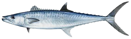
Scientific Name
Scomberomorus cavalla
Common Name
Kingfish
Stock Status
Overfishing – No
Overfished – No
Recreational Regulations
Federal Regulations
-
Open year-round
- 3 Bag Limit
- Minimum Size: 24 in Fork Length
Notes: To see commercial regulations, download Fish Rules Commercial App for iOS devices or Android devices.
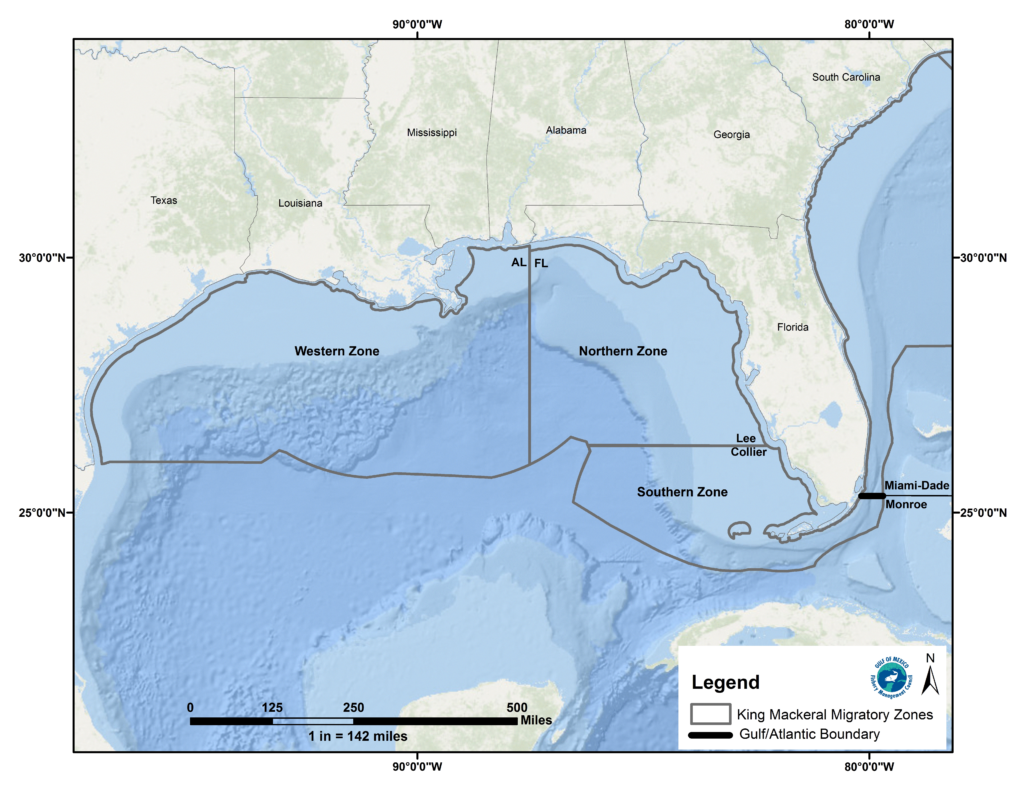
Commercial Regulations
Gillnet for King Mackerel – Gulf of Mexico Southern Zone
-
Closed: January 01 – January 16
Open: January 17 – December 31
- Minimum Size: 24 in Fork Length
- Maximum Size: None
- 45,000 lbs Mixed Weight Trip Limit
- Quota: Zone Commercial ACL – 671,328 lbs MW
0% harvested Notes:
Opens at 6:00 a.m. the day after the Martin Luther King Jr. Federal Holiday. Open the first weekend and remains open on weekdays only until the quota is met.
A vessel with a valid commercial king mackerel permit may transit through areas closed to harvest of king mackerel with king mackerel onboard if fishing gear is properly stowed. No more than two king mackerel per crew member may be retained or sold per trip.
Minimum size 24-inches fork length. Exception: a vessel fishing under a quota for king mackerel may possess no more than 5%, by weight, of undersized king mackerel. Cut-off (damaged) king mackerel that comply with minimum size limits and trip limits may be possessed on vessels operating under trip limits and sold. A maximum of five additional cut-off king mackerel not subject to size or trip limits may be possessed and offloaded but may not be sold.
The use of run-around gillnets for king mackerel is only permitted in the Southern zone.
Areas
Alabama Alps Reef
Alabama Alps Reef HAPC is bounded by rhumb lines connecting the following points in order: 29°16.160′ 88°20.525′ 29°15.427′ 88°18.990′ 29°13.380′ 88°19.051′ 29°14.140′ 88°20.533′ 29°16.160′ 88°20.525′Deployment of a bottom longline, bottom trawl, buoy gear, dredge, pot, or trap, and bottom anchoring by fishing vessels are prohibited year-round in the area of the HAPC.
West Flower Garden Banks
West Flower Garden Bank is bounded by rhumb lines connecting, in order, the following points: 27°55′22.8″ 93°53′09.6″; 27°55′22.8″ 93°46′46.0″; 27°49′03.0″ 93°46′46.0″; 27°49′03.0″ 93°53′09.6″; 27°55′22.8″ 93°53′09.6″.Deployment of bottom longline, bottom trawl, buoy gear, dredge, pot, or trap and bottom anchoring by fishing vessels is prohibited year-round.
West Florida Wall
West Florida Wall HAPC is bounded by rhumb lines connecting the following points in order: 26°28.835′ 84°47.955′; 26°28.816′ 84°46.754′; 26°10.471′ 84°42.076′; 26°10.528′ 84°44.577′; 26°25.028′ 84°47.986′; 26°25.100′ 84°47.980′; 26°28.835′ 84°47.955′.Deployment of bottom-tending gear (bottom longline, bottom trawl, buoy gear, dredge, pot or trap) and bottom anchoring by fishing vessels is prohibited year-round.
Viosca Knoll 862/906
Viosca Knoll 862/906 HAPC is bounded by rhumb lines connecting the following points in order: 29°07.640′ 88°23.608′; 29°07.603′ 88°20.590′; 29°03.749′ 88°20.554′; 29°03.734′ 88°22.016′; 29°02.367′ 88°21.998′; 29°02.281′ 88°24.972′; 29°07.568′ 88°25.044′; 29°07.592′ 88°25.044′; 29°07.676′ 88°25.045′; 29°07.640′ 88°23.608′.Deployment of a bottom longline, bottom trawl, buoy gear, dredge, pot, or trap, and bottom anchoring by fishing vessels are prohibited year-round in the area of the HAPC. This prohibition does not apply to a fishing vessel issued a Gulf royal red shrimp endorsement, as specified in §622.50(c), while the vessel is fishing for royal red shrimp.
Viosca Knoll 826
Viosca Knoll 826 HAPC is bounded by rhumb lines connecting the following points in order: 29°10.920′ 88°03.509′; 29°10.877′ 87°59.460′; 29°07.974′ 87°59.448′; 29°08.017′ 88°03.532′; 29°10.920′ 88°03.509′.Deployment of a bottom longline, bottom trawl, buoy gear, dredge, pot, or trap, and bottom anchoring by fishing vessels are prohibited year-round in the HAPC.
Tortugas South
Tortugas South area is bounded by rhumb lines connecting, in order, the following points: 24°33′00″ 83°09′00″; 24°33′00″ 83°05′00″; 24°18′00″ 83°05′00″; 24°18′00″ 83°09′00″; 24°33′00″ 83°09′00″.Fishing for any species and bottom anchoring by fishing vessels is prohibited year-round.
The Edges
The Edges is bounded by rhumb lines connecting, in order, the following points: 28°51′ 85°16′; 28°51′ 85°04′; 28°14′ 84°42′; 28°14′ 84°54′; 28°51′ 85°16′.All fishing prohibited January through April. Possession of any fish species is prohibited January through April, except when in transit with fishing gear stowed.
Stetson Bank
Stetson Bank HAPC is bounded by rhumb lines connecting, in order, the following points: 28°10′38.3″ 94°18′36.5″; 28°10′38.3″ 94°17′06.3″; 28°09′18.6″ 94°17′06.3″; 28°09′18.6″ 94°18′36.5″; 28°10′38.3″ 94°18′36.5″.Deployment of bottom longline, bottom trawl, buoy gear, pot, or trap and bottom anchoring by fishing vessels is prohibited year-round.
Steamboat Lumps
Steamboat Lumps is bounded by rhumb lines connecting, in order, the following points: 28°14′ 84°48′; 28°14′ 84°37′; 28°03′ 84°37′; 28°03′ 84°48′'; 28°14′ 84°48′.Possession of Reef Fish prohibited year-round, except when in transit with fishing gear stowed. Possession of all fish is prohibited November through April, except when in transit with fishing gear stowed. All Fishing Prohibited with the exception of surface trawling which is allowed May through October.
Southern Bank
Southern Bank HAPC is bounded by rhumb lines connecting the following points in order: 27°26.923′ 96°31.902′; 27°26.989′ 96°30.881′; 27°25.958′ 96°31.134′; 27°25.958′ 96°31.892′; 27°26.923′ 96°31.902′.Deployment of a bottom longline, bottom trawl, buoy gear, dredge, pot, or trap, and bottom anchoring by fishing vessels are prohibited year-round in the HAPC.
Roughtounge Reef
Roughtongue Reef HAPC is bounded by rhumb lines connecting the following points in order: 29°27.596′ 87°37.527′; 29°27.621′ 87°31.552′; 29°25.007′ 87°31.539′; 29°24.981′ 87°37.510′; 29°27.596′ 87°37.527′.Deployment of a bottom longline, bottom trawl, buoy gear, dredge, pot, or trap, and bottom anchoring by fishing vessels are prohibited year-round in the HAPC.
Pulley Ridge South Portion A
Pulley Ridge South Portion A HAPC is bounded by rhumb lines connecting the following points in order: 24°40.000′ 83°41.366′; 24°39.666′ 83°42.648′; 24°47.555′ 83°55.240′; 24°57.065′ 83°48.405′; 24°52.859′ 83°41.841′; 24°43.917′ 83°47.250′; 24°40.000′ 83°41.366′.Deployment of a bottom trawl, buoy gear, dredge, pot, or trap, and bottom anchoring by fishing vessels are prohibited year-round in the HAPC.
Pulley Ridge
Pulley Ridge HAPC is bounded by rhumb lines connecting the following points: A 24°58′18″ 83°38′33″; B 24°58′18″ 83°37′00″; C 24°41′11″ 83°37′00″; D 24°40′00″ 83°41′22″; E 24°43′55″ 83°47′15″; A 24°58′18″ 83°38′33″.Deployment of bottom longline, bottom trawl, buoy gear, pot, or trap and bottom anchoring by fishing vessels is prohibited year-round.
Mississippi Canyon 118
Mississippi Canyon 118 HAPC is bounded by rhumb lines connecting the following points in order: 28°53.183′ 88°30.789′; 28°53.216′ 88°27.819′; 28°50.602′88°27.782′; 28°48.944′ 88°27.759′; 28°48.962′ 88°30.727′; 28°53.183′ 88°30.789′.Deployment of a bottom longline, bottom trawl, buoy gear, dredge, pot, or trap, and bottom anchoring by fishing vessels are prohibited year-round in the HAPC.
McGrail Bank
McGrail Bank HAPC is bounded by rhumb lines connecting, in order, the following points: 27°59′06.0″ 92°37′19.2″; 27°59′06.0″ 92°32′17.4″; 27°55′55.5″ 92°32′17.4″; 27°55′55.5″ 92°37′19.2″; 27°59′06.0″ 92°37′19.2″.Deployment of bottom longline, bottom trawl, buoy gear, pot, or trap and bottom anchoring by fishing vessels is prohibited year-round.
Madison Swanson
The Madison and Swanson sites are bounded by rhumb lines connecting, in order, the following points: 29°17′ 85°50′; 29°17′ 85°38′; 29°06′ 85°38′; 29°06′ 85°50′; 29°17′ 85°50′.Fishing prohibited year-round. Possession of reef fish prohibited even for vessels in transit unless the vessel has an operating vessel monitoring system, a valid federal commercial Gulf of Mexico Reef Fish Permit, and fishing gear is appropriately stowed. These prohibitions do not apply to Atlantic Highly Migratory Species.
L&W Pinnacles and Scamp Reef
L & W Pinnacles and Scamp Reef HAPC is bounded by rhumb lines connecting the following points in order: 29°18.595′ 87°48.757′; 29°18.484′ 87°50.688′; 29°19.754′ 87°52.484′; 29°20.401′ 87°51.449′; 29°20.095′ 87°50.933′; 29°20.832′ 87°46.631′; 29°21.473′ 87°46.326′; 29°21.314′ 87°45.535′; 29°22.518′ 87°43.465′; 29°21.144′ 87°42.632′; 29°19.269′ 87°45.525′; 29°18.595′ 87°48.757′.Deployment of a bottom longline, bottom trawl, buoy gear, dredge, pot, or trap, and bottom anchoring by fishing vessels are prohibited year-round in the area of the HAPC.
Harte Bank
Harte Bank HAPC is bounded by rhumb lines connecting the following points in order: 26°40.826′ 96°36.590′; 26°40.789′ 96°32.220′; 26°37.992′ 96°32.308′; 26°38.043′ 96°36.636′; 26°40.826′ 96°36.590′.Deployment of a bottom longline, bottom trawl, buoy gear, dredge, pot, or trap, and bottom anchoring by fishing vessels are prohibited year-round in the HAPC.
Green Canyon 852
Green Canyon 852 HAPC is bounded by rhumb lines connecting the following points in order: 27°08.354′ 91°08.929′; 27°05.740′ 91°08.963′; 27°05.762′ 91°10.610′; 27°08.376′ 91°10.567′; 27°08.354′ 91°08.929′.Deployment of a bottom longline, bottom trawl, buoy gear, dredge, pot, or trap, and bottom anchoring by fishing vessels are prohibited year-round in the HAPC.
Florida Middle Grounds
Florida Middle Grounds HAPC is the area bounded by rhumb lines connecting the following points: 28°42.5′ N 84°24.8′ W28°42.5′ N 84°16.3′ W28°11.0′ N 84°00.0′ W28°11.0′ N 84°07.0′ W28°26.6′ N 84°24.8′ W28°42.5′ N 84°24.8′ WDeployment of bottom longline, bottom trawl, dredge, pot, or trap is prohibited year-round.
EEZ Tortugas North
The area is bounded by rhumb lines connecting the following points: From point A at 24°40′00″ N. lat., 83°06′00″ W. long. to point B at 24°46′00″ N. lat., 83°06′00″ W. long. to point C at 24°46′00″ N. lat., 83°00′00″ W. long.; thence along the line denoting the seaward limit of Florida's waters, as shown on the current edition of NOAA chart 11434, to point A at 24°40′00″ N. lat., 83°06′00″ W. long.Fishing for any species and bottom anchoring by fishing vessels is prohibited year-round.
East Flower Garden Banks
East Flower Garden Bank is bounded by rhumb lines connecting, in order, the following points: 27°59′14.4″ N 93°38′58.2″ W27°59′14.4″ N 93°34′03.5″ W27°52′36.5″ N 93°34′03.5″ W27°52′36.5″ N 93°38′58.2″ W27°59′14.4″ N 93°38′58.2″ WDeployment of bottom longline, bottom trawl, buoy gear, dredge, pot, or trap and bottom anchoring by fishing vessels is prohibited year-round.
AT 357
AT 357 HAPC is bounded by rhumb lines connecting the following points in order: 27°36.259' N 89°43.068' W 27°36.315' N 89°40.136' W27°33.703' N 89°40.073' W27°33.646' N 89°43.004' WDeployment of a bottom longline, bottom trawl, buoy gear, dredge, pot, or trap, and bottom anchoring by fishing vessels are prohibited year-round in the HAPC.
AT 047
AT 047 HAPC is bounded by rhumb lines connecting the following points in order: 27°54.426′ N 89°49.404′ W27°54.486′ N 89°46.464′ W27°51.874′ N 89°46.397′ W27°51.814′ N 89°49.336′ WDeployment of a bottom longline, bottom trawl, buoy gear, dredge, pot, or trap and bottom anchoring by fishing vessels are prohibited year-round in the HAPC.
Conditions
General Info
This is a limited access permit – new permits are not issued and you can only obtain a permit by purchasing one from an existing permit holder.For a person aboard a vessel to use a run-around gillnet for king mackerel in the southern zone (see §622.369(a)(1)(iii)), a commercial vessel permit for king mackerel and a king mackerel gillnet permit must have been issued to the vessel and must be on board. See §622.372 regarding a limited access system applicable to king mackerel gillnet permits in the southern zone and restrictions on transferability of king mackerel gillnet permits.
Sale Purchase Restrictions
A king or Spanish mackerel harvested or possessed in the EEZ on board a vessel that does not have a valid commercial vessel permit for king mackerel, as required under §622.370(a)(1), or a valid commercial vessel permit for Spanish mackerel, as required under §622.370(a)(3), or a king or Spanish mackerel harvested in the EEZ or possessed under the bag limits specified in §622.382, may not be sold or purchased, except when harvested under the bag limits on board a vessel operating in the Gulf as a charter vessel or headboat and that vessel has both a valid Federal charter vessel/headboat permit for Gulf coastal migratory pelagic fish, as required under §622.370(b)(1), and a valid commercial vessel permit for king mackerel or Spanish mackerel, as required under §622.370(a)(1), as appropriate to the species harvested or possessed.Coastal migratory pelagic fish harvested in or from the EEZ or adjoining state waters by a vessel that has a valid Federal commercial vessel permit or a charter vessel/headboat permit may be sold or transferred only to a dealer who has a valid Gulf and South Atlantic dealer permit, as required under §622.370(c)(1).Coastal migratory pelagic fish harvested in or from the Gulf or South Atlantic EEZ may be first received by a dealer who has a valid Gulf and South Atlantic dealer permit, as required under §622.370(c)(1), only from a vessel that has a valid Federal commercial vessel permit, as required under §622.370(a), or a charter vessel/headboat permit for coastal migratory pelagic fish, as required under §622.370(b).Cut-off (damaged) king or Spanish mackerel. A person may not sell or purchase a cut-off (damaged) king or Spanish mackerel that does not comply with the minimum size limits specified in §622.380(b) or (c), respectively, or that is in excess.
King Mackerel Permit – Gulf of Mexico Western Zone
-
Fishing year begins Jul 1
Open year-round
- Minimum Size: 24 in Fork Length
- Maximum Size: None
- 3,000 lbs Mixed Weight Trip Limit
- Quota: Zone Commercial ACL – 1,278,720 lbs MW
0.9% harvested Notes:
A vessel with a valid commercial king mackerel permit may transit through areas closed to harvest of king mackerel with king mackerel onboard if fishing gear is properly stowed.
Minimum size 24-inches fork length. Exception: a vessel fishing under a quota for king mackerel may possess no more than 5%, by weight, of undersized king mackerel. Cut-off (damaged) king mackerel that comply with minimum size limits and trip limits may be possessed on vessels operating under trip limits and sold. A maximum of five additional cut-off king mackerel not subject to size or trip limits may be possessed and offloaded but may not be sold.
Areas
Alabama Alps Reef
Alabama Alps Reef HAPC is bounded by rhumb lines connecting the following points in order: 29°16.160′ 88°20.525′ 29°15.427′ 88°18.990′ 29°13.380′ 88°19.051′ 29°14.140′ 88°20.533′ 29°16.160′ 88°20.525′Deployment of a bottom longline, bottom trawl, buoy gear, dredge, pot, or trap, and bottom anchoring by fishing vessels are prohibited year-round in the area of the HAPC.
West Flower Garden Banks
West Flower Garden Bank is bounded by rhumb lines connecting, in order, the following points: 27°55′22.8″ 93°53′09.6″; 27°55′22.8″ 93°46′46.0″; 27°49′03.0″ 93°46′46.0″; 27°49′03.0″ 93°53′09.6″; 27°55′22.8″ 93°53′09.6″.Deployment of bottom longline, bottom trawl, buoy gear, dredge, pot, or trap and bottom anchoring by fishing vessels is prohibited year-round.
West Florida Wall
West Florida Wall HAPC is bounded by rhumb lines connecting the following points in order: 26°28.835′ 84°47.955′; 26°28.816′ 84°46.754′; 26°10.471′ 84°42.076′; 26°10.528′ 84°44.577′; 26°25.028′ 84°47.986′; 26°25.100′ 84°47.980′; 26°28.835′ 84°47.955′.Deployment of bottom-tending gear (bottom longline, bottom trawl, buoy gear, dredge, pot or trap) and bottom anchoring by fishing vessels is prohibited year-round.
Viosca Knoll 862/906
Viosca Knoll 862/906 HAPC is bounded by rhumb lines connecting the following points in order: 29°07.640′ 88°23.608′; 29°07.603′ 88°20.590′; 29°03.749′ 88°20.554′; 29°03.734′ 88°22.016′; 29°02.367′ 88°21.998′; 29°02.281′ 88°24.972′; 29°07.568′ 88°25.044′; 29°07.592′ 88°25.044′; 29°07.676′ 88°25.045′; 29°07.640′ 88°23.608′.Deployment of a bottom longline, bottom trawl, buoy gear, dredge, pot, or trap, and bottom anchoring by fishing vessels are prohibited year-round in the area of the HAPC. This prohibition does not apply to a fishing vessel issued a Gulf royal red shrimp endorsement, as specified in §622.50(c), while the vessel is fishing for royal red shrimp.
Viosca Knoll 826
Viosca Knoll 826 HAPC is bounded by rhumb lines connecting the following points in order: 29°10.920′ 88°03.509′; 29°10.877′ 87°59.460′; 29°07.974′ 87°59.448′; 29°08.017′ 88°03.532′; 29°10.920′ 88°03.509′.Deployment of a bottom longline, bottom trawl, buoy gear, dredge, pot, or trap, and bottom anchoring by fishing vessels are prohibited year-round in the HAPC.
Tortugas South
Tortugas South area is bounded by rhumb lines connecting, in order, the following points: 24°33′00″ 83°09′00″; 24°33′00″ 83°05′00″; 24°18′00″ 83°05′00″; 24°18′00″ 83°09′00″; 24°33′00″ 83°09′00″.Fishing for any species and bottom anchoring by fishing vessels is prohibited year-round.
The Edges
The Edges is bounded by rhumb lines connecting, in order, the following points: 28°51′ 85°16′; 28°51′ 85°04′; 28°14′ 84°42′; 28°14′ 84°54′; 28°51′ 85°16′.All fishing prohibited January through April. Possession of any fish species is prohibited January through April, except when in transit with fishing gear stowed.
Stetson Bank
Stetson Bank HAPC is bounded by rhumb lines connecting, in order, the following points: 28°10′38.3″ 94°18′36.5″; 28°10′38.3″ 94°17′06.3″; 28°09′18.6″ 94°17′06.3″; 28°09′18.6″ 94°18′36.5″; 28°10′38.3″ 94°18′36.5″.Deployment of bottom longline, bottom trawl, buoy gear, pot, or trap and bottom anchoring by fishing vessels is prohibited year-round.
Steamboat Lumps
Steamboat Lumps is bounded by rhumb lines connecting, in order, the following points: 28°14′ 84°48′; 28°14′ 84°37′; 28°03′ 84°37′; 28°03′ 84°48′'; 28°14′ 84°48′.Possession of Reef Fish prohibited year-round, except when in transit with fishing gear stowed. Possession of all fish is prohibited November through April, except when in transit with fishing gear stowed. All Fishing Prohibited with the exception of surface trawling which is allowed May through October.
Southern Bank
Southern Bank HAPC is bounded by rhumb lines connecting the following points in order: 27°26.923′ 96°31.902′; 27°26.989′ 96°30.881′; 27°25.958′ 96°31.134′; 27°25.958′ 96°31.892′; 27°26.923′ 96°31.902′.Deployment of a bottom longline, bottom trawl, buoy gear, dredge, pot, or trap, and bottom anchoring by fishing vessels are prohibited year-round in the HAPC.
Roughtounge Reef
Roughtongue Reef HAPC is bounded by rhumb lines connecting the following points in order: 29°27.596′ 87°37.527′; 29°27.621′ 87°31.552′; 29°25.007′ 87°31.539′; 29°24.981′ 87°37.510′; 29°27.596′ 87°37.527′.Deployment of a bottom longline, bottom trawl, buoy gear, dredge, pot, or trap, and bottom anchoring by fishing vessels are prohibited year-round in the HAPC.
Pulley Ridge South Portion A
Pulley Ridge South Portion A HAPC is bounded by rhumb lines connecting the following points in order: 24°40.000′ 83°41.366′; 24°39.666′ 83°42.648′; 24°47.555′ 83°55.240′; 24°57.065′ 83°48.405′; 24°52.859′ 83°41.841′; 24°43.917′ 83°47.250′; 24°40.000′ 83°41.366′.Deployment of a bottom trawl, buoy gear, dredge, pot, or trap, and bottom anchoring by fishing vessels are prohibited year-round in the HAPC.
Pulley Ridge
Pulley Ridge HAPC is bounded by rhumb lines connecting the following points: A 24°58′18″ 83°38′33″; B 24°58′18″ 83°37′00″; C 24°41′11″ 83°37′00″; D 24°40′00″ 83°41′22″; E 24°43′55″ 83°47′15″; A 24°58′18″ 83°38′33″.Deployment of bottom longline, bottom trawl, buoy gear, pot, or trap and bottom anchoring by fishing vessels is prohibited year-round.
Mississippi Canyon 118
Mississippi Canyon 118 HAPC is bounded by rhumb lines connecting the following points in order: 28°53.183′ 88°30.789′; 28°53.216′ 88°27.819′; 28°50.602′88°27.782′; 28°48.944′ 88°27.759′; 28°48.962′ 88°30.727′; 28°53.183′ 88°30.789′.Deployment of a bottom longline, bottom trawl, buoy gear, dredge, pot, or trap, and bottom anchoring by fishing vessels are prohibited year-round in the HAPC.
McGrail Bank
McGrail Bank HAPC is bounded by rhumb lines connecting, in order, the following points: 27°59′06.0″ 92°37′19.2″; 27°59′06.0″ 92°32′17.4″; 27°55′55.5″ 92°32′17.4″; 27°55′55.5″ 92°37′19.2″; 27°59′06.0″ 92°37′19.2″.Deployment of bottom longline, bottom trawl, buoy gear, pot, or trap and bottom anchoring by fishing vessels is prohibited year-round.
Madison Swanson
The Madison and Swanson sites are bounded by rhumb lines connecting, in order, the following points: 29°17′ 85°50′; 29°17′ 85°38′; 29°06′ 85°38′; 29°06′ 85°50′; 29°17′ 85°50′.Fishing prohibited year-round. Possession of reef fish prohibited even for vessels in transit unless the vessel has an operating vessel monitoring system, a valid federal commercial Gulf of Mexico Reef Fish Permit, and fishing gear is appropriately stowed. These prohibitions do not apply to Atlantic Highly Migratory Species.
L&W Pinnacles and Scamp Reef
L & W Pinnacles and Scamp Reef HAPC is bounded by rhumb lines connecting the following points in order: 29°18.595′ 87°48.757′; 29°18.484′ 87°50.688′; 29°19.754′ 87°52.484′; 29°20.401′ 87°51.449′; 29°20.095′ 87°50.933′; 29°20.832′ 87°46.631′; 29°21.473′ 87°46.326′; 29°21.314′ 87°45.535′; 29°22.518′ 87°43.465′; 29°21.144′ 87°42.632′; 29°19.269′ 87°45.525′; 29°18.595′ 87°48.757′.Deployment of a bottom longline, bottom trawl, buoy gear, dredge, pot, or trap, and bottom anchoring by fishing vessels are prohibited year-round in the area of the HAPC.
Harte Bank
Harte Bank HAPC is bounded by rhumb lines connecting the following points in order: 26°40.826′ 96°36.590′; 26°40.789′ 96°32.220′; 26°37.992′ 96°32.308′; 26°38.043′ 96°36.636′; 26°40.826′ 96°36.590′.Deployment of a bottom longline, bottom trawl, buoy gear, dredge, pot, or trap, and bottom anchoring by fishing vessels are prohibited year-round in the HAPC.
Green Canyon 852
Green Canyon 852 HAPC is bounded by rhumb lines connecting the following points in order: 27°08.354′ 91°08.929′; 27°05.740′ 91°08.963′; 27°05.762′ 91°10.610′; 27°08.376′ 91°10.567′; 27°08.354′ 91°08.929′.Deployment of a bottom longline, bottom trawl, buoy gear, dredge, pot, or trap, and bottom anchoring by fishing vessels are prohibited year-round in the HAPC.
Florida Middle Grounds
Florida Middle Grounds HAPC is the area bounded by rhumb lines connecting the following points: 28°42.5′ N 84°24.8′ W28°42.5′ N 84°16.3′ W28°11.0′ N 84°00.0′ W28°11.0′ N 84°07.0′ W28°26.6′ N 84°24.8′ W28°42.5′ N 84°24.8′ WDeployment of bottom longline, bottom trawl, dredge, pot, or trap is prohibited year-round.
EEZ Tortugas North
The area is bounded by rhumb lines connecting the following points: From point A at 24°40′00″ N. lat., 83°06′00″ W. long. to point B at 24°46′00″ N. lat., 83°06′00″ W. long. to point C at 24°46′00″ N. lat., 83°00′00″ W. long.; thence along the line denoting the seaward limit of Florida's waters, as shown on the current edition of NOAA chart 11434, to point A at 24°40′00″ N. lat., 83°06′00″ W. long.Fishing for any species and bottom anchoring by fishing vessels is prohibited year-round.
East Flower Garden Banks
East Flower Garden Bank is bounded by rhumb lines connecting, in order, the following points: 27°59′14.4″ N 93°38′58.2″ W27°59′14.4″ N 93°34′03.5″ W27°52′36.5″ N 93°34′03.5″ W27°52′36.5″ N 93°38′58.2″ W27°59′14.4″ N 93°38′58.2″ WDeployment of bottom longline, bottom trawl, buoy gear, dredge, pot, or trap and bottom anchoring by fishing vessels is prohibited year-round.
AT 357
AT 357 HAPC is bounded by rhumb lines connecting the following points in order: 27°36.259' N 89°43.068' W 27°36.315' N 89°40.136' W27°33.703' N 89°40.073' W27°33.646' N 89°43.004' WDeployment of a bottom longline, bottom trawl, buoy gear, dredge, pot, or trap, and bottom anchoring by fishing vessels are prohibited year-round in the HAPC.
AT 047
AT 047 HAPC is bounded by rhumb lines connecting the following points in order: 27°54.426′ N 89°49.404′ W27°54.486′ N 89°46.464′ W27°51.874′ N 89°46.397′ W27°51.814′ N 89°49.336′ WDeployment of a bottom longline, bottom trawl, buoy gear, dredge, pot, or trap and bottom anchoring by fishing vessels are prohibited year-round in the HAPC.
Conditions
Reporting
The owner or operator of a vessel that fishes for or lands coastal migratory pelagic fish for sale in or from the Gulf, Mid-Atlantic, or South Atlantic EEZ or adjoining state waters, or whose vessel is issued a commercial permit for king or Spanish mackerel, as required under §622.370(a)(1) or (3), respectively, who is selected to report, must maintain a logbook on a form available from NOAA Fisheries.These completed fishing records must be submitted to NOAA Fisheries postmarked no later than 7 days after the end of each fishing trip. If no fishing occurred during a calendar month, a report so stating must be submitted on one of the forms postmarked no later than 7 days after the end of that month. Information to be reported is indicated on the form and its accompanying instructions.Contact 305-361-4581 for assistance with commercial logbooks.
Harvest Limitations
A person who fishes in the EEZ may not combine federal harvest with harvest applicable to state waters. Species may not be transferred at sea.
Recreational Bag Limit
If the recreational sector for the applicable migratory group, zone, or gear is open, the bag and possession limits for Spanish mackerel apply to all harvest or possession for the closed species, migratory group, zone, or gear in or from the EEZ. If the recreational sector for the applicable species, migratory group, zone, or gear is closed, all applicable harvest or possession in or from the EEZ is prohibited.
Sale Purchase Restrictions
A king or Spanish mackerel harvested or possessed in the EEZ on board a vessel that does not have a valid commercial vessel permit for king mackerel, as required under §622.370(a)(1), or a valid commercial vessel permit for Spanish mackerel, as required under §622.370(a)(3), or a king or Spanish mackerel harvested in the EEZ or possessed under the bag limits specified in §622.382, may not be sold or purchased, except when harvested under the bag limits on board a vessel operating in the Gulf as a charter vessel or headboat and that vessel has both a valid Federal charter vessel/headboat permit for Gulf coastal migratory pelagic fish, as required under §622.370(b)(1), and a valid commercial vessel permit for king mackerel or Spanish mackerel, as required under §622.370(a)(1), as appropriate to the species harvested or possessed.Coastal migratory pelagic fish harvested in or from the EEZ or adjoining state waters by a vessel that has a valid Federal commercial vessel permit or a charter vessel/headboat permit may be sold or transferred only to a dealer who has a valid Gulf and South Atlantic dealer permit, as required under §622.370(c)(1).Coastal migratory pelagic fish harvested in or from the Gulf or South Atlantic EEZ may be first received by a dealer who has a valid Gulf and South Atlantic dealer permit, as required under §622.370(c)(1), only from a vessel that has a valid Federal commercial vessel permit, as required under §622.370(a), or a charter vessel/headboat permit for coastal migratory pelagic fish, as required under §622.370(b).Cut-off (damaged) king or Spanish mackerel. A person may not sell or purchase a cut-off (damaged) king or Spanish mackerel that does not comply with the minimum size limits specified in §622.380(b) or (c), respectively, or that is in excess.
Landing Fish Intact
Cut-off (damaged) king mackerel that comply with minimum size limits and trip limits may be possessed on vessels operating under trip limits and sold. A maximum of five additional cut-off king mackerel not subject to size or trip limits may be possessed and offloaded but may not be sold.
Authorized Gear
A run-around gillnet with mesh no smaller than 4.75 inches.
Authorized Gear
For Atlantic king mackerel north of the Cape Lookout, NC Light (34° 37.3' N. lat.) all gear is authorized except for drift gillnets and long gillnets.South of the Cape Lookout Light the following gear is authorized:automatic reel,bandit gear,handline,rod and reel.
King Mackerel Permit – Gulf of Mexico Southern Zone
-
Fishing year begins Jul 1
Open year-round
- Minimum Size: 24 in Fork Length
- Maximum Size: None
- 1,250 lbs Mixed Weight Trip Limit
- Quota: Zone Commercial ACL – 671,328 lbs MW
0.1% harvested Notes:
A vessel with a valid commercial king mackerel permit may transit through areas closed to harvest of king mackerel with king mackerel onboard if fishing gear is properly stowed.
Minimum size 24-inches fork length. Exception: a vessel fishing under a quota for king mackerel may possess no more than 5%, by weight, of undersized king mackerel. Cut-off (damaged) king mackerel that comply with minimum size limits and trip limits may be possessed on vessels operating under trip limits and sold. A maximum of five additional cut-off king mackerel not subject to size or trip limits may be possessed and offloaded but may not be sold.
Areas
Alabama Alps Reef
Alabama Alps Reef HAPC is bounded by rhumb lines connecting the following points in order: 29°16.160′ 88°20.525′ 29°15.427′ 88°18.990′ 29°13.380′ 88°19.051′ 29°14.140′ 88°20.533′ 29°16.160′ 88°20.525′Deployment of a bottom longline, bottom trawl, buoy gear, dredge, pot, or trap, and bottom anchoring by fishing vessels are prohibited year-round in the area of the HAPC.
West Flower Garden Banks
West Flower Garden Bank is bounded by rhumb lines connecting, in order, the following points: 27°55′22.8″ 93°53′09.6″; 27°55′22.8″ 93°46′46.0″; 27°49′03.0″ 93°46′46.0″; 27°49′03.0″ 93°53′09.6″; 27°55′22.8″ 93°53′09.6″.Deployment of bottom longline, bottom trawl, buoy gear, dredge, pot, or trap and bottom anchoring by fishing vessels is prohibited year-round.
West Florida Wall
West Florida Wall HAPC is bounded by rhumb lines connecting the following points in order: 26°28.835′ 84°47.955′; 26°28.816′ 84°46.754′; 26°10.471′ 84°42.076′; 26°10.528′ 84°44.577′; 26°25.028′ 84°47.986′; 26°25.100′ 84°47.980′; 26°28.835′ 84°47.955′.Deployment of bottom-tending gear (bottom longline, bottom trawl, buoy gear, dredge, pot or trap) and bottom anchoring by fishing vessels is prohibited year-round.
Viosca Knoll 862/906
Viosca Knoll 862/906 HAPC is bounded by rhumb lines connecting the following points in order: 29°07.640′ 88°23.608′; 29°07.603′ 88°20.590′; 29°03.749′ 88°20.554′; 29°03.734′ 88°22.016′; 29°02.367′ 88°21.998′; 29°02.281′ 88°24.972′; 29°07.568′ 88°25.044′; 29°07.592′ 88°25.044′; 29°07.676′ 88°25.045′; 29°07.640′ 88°23.608′.Deployment of a bottom longline, bottom trawl, buoy gear, dredge, pot, or trap, and bottom anchoring by fishing vessels are prohibited year-round in the area of the HAPC. This prohibition does not apply to a fishing vessel issued a Gulf royal red shrimp endorsement, as specified in §622.50(c), while the vessel is fishing for royal red shrimp.
Viosca Knoll 826
Viosca Knoll 826 HAPC is bounded by rhumb lines connecting the following points in order: 29°10.920′ 88°03.509′; 29°10.877′ 87°59.460′; 29°07.974′ 87°59.448′; 29°08.017′ 88°03.532′; 29°10.920′ 88°03.509′.Deployment of a bottom longline, bottom trawl, buoy gear, dredge, pot, or trap, and bottom anchoring by fishing vessels are prohibited year-round in the HAPC.
Tortugas South
Tortugas South area is bounded by rhumb lines connecting, in order, the following points: 24°33′00″ 83°09′00″; 24°33′00″ 83°05′00″; 24°18′00″ 83°05′00″; 24°18′00″ 83°09′00″; 24°33′00″ 83°09′00″.Fishing for any species and bottom anchoring by fishing vessels is prohibited year-round.
The Edges
The Edges is bounded by rhumb lines connecting, in order, the following points: 28°51′ 85°16′; 28°51′ 85°04′; 28°14′ 84°42′; 28°14′ 84°54′; 28°51′ 85°16′.All fishing prohibited January through April. Possession of any fish species is prohibited January through April, except when in transit with fishing gear stowed.
Stetson Bank
Stetson Bank HAPC is bounded by rhumb lines connecting, in order, the following points: 28°10′38.3″ 94°18′36.5″; 28°10′38.3″ 94°17′06.3″; 28°09′18.6″ 94°17′06.3″; 28°09′18.6″ 94°18′36.5″; 28°10′38.3″ 94°18′36.5″.Deployment of bottom longline, bottom trawl, buoy gear, pot, or trap and bottom anchoring by fishing vessels is prohibited year-round.
Steamboat Lumps
Steamboat Lumps is bounded by rhumb lines connecting, in order, the following points: 28°14′ 84°48′; 28°14′ 84°37′; 28°03′ 84°37′; 28°03′ 84°48′'; 28°14′ 84°48′.Possession of Reef Fish prohibited year-round, except when in transit with fishing gear stowed. Possession of all fish is prohibited November through April, except when in transit with fishing gear stowed. All Fishing Prohibited with the exception of surface trawling which is allowed May through October.
Southern Bank
Southern Bank HAPC is bounded by rhumb lines connecting the following points in order: 27°26.923′ 96°31.902′; 27°26.989′ 96°30.881′; 27°25.958′ 96°31.134′; 27°25.958′ 96°31.892′; 27°26.923′ 96°31.902′.Deployment of a bottom longline, bottom trawl, buoy gear, dredge, pot, or trap, and bottom anchoring by fishing vessels are prohibited year-round in the HAPC.
Roughtounge Reef
Roughtongue Reef HAPC is bounded by rhumb lines connecting the following points in order: 29°27.596′ 87°37.527′; 29°27.621′ 87°31.552′; 29°25.007′ 87°31.539′; 29°24.981′ 87°37.510′; 29°27.596′ 87°37.527′.Deployment of a bottom longline, bottom trawl, buoy gear, dredge, pot, or trap, and bottom anchoring by fishing vessels are prohibited year-round in the HAPC.
Pulley Ridge South Portion A
Pulley Ridge South Portion A HAPC is bounded by rhumb lines connecting the following points in order: 24°40.000′ 83°41.366′; 24°39.666′ 83°42.648′; 24°47.555′ 83°55.240′; 24°57.065′ 83°48.405′; 24°52.859′ 83°41.841′; 24°43.917′ 83°47.250′; 24°40.000′ 83°41.366′.Deployment of a bottom trawl, buoy gear, dredge, pot, or trap, and bottom anchoring by fishing vessels are prohibited year-round in the HAPC.
Pulley Ridge
Pulley Ridge HAPC is bounded by rhumb lines connecting the following points: A 24°58′18″ 83°38′33″; B 24°58′18″ 83°37′00″; C 24°41′11″ 83°37′00″; D 24°40′00″ 83°41′22″; E 24°43′55″ 83°47′15″; A 24°58′18″ 83°38′33″.Deployment of bottom longline, bottom trawl, buoy gear, pot, or trap and bottom anchoring by fishing vessels is prohibited year-round.
Mississippi Canyon 118
Mississippi Canyon 118 HAPC is bounded by rhumb lines connecting the following points in order: 28°53.183′ 88°30.789′; 28°53.216′ 88°27.819′; 28°50.602′88°27.782′; 28°48.944′ 88°27.759′; 28°48.962′ 88°30.727′; 28°53.183′ 88°30.789′.Deployment of a bottom longline, bottom trawl, buoy gear, dredge, pot, or trap, and bottom anchoring by fishing vessels are prohibited year-round in the HAPC.
McGrail Bank
McGrail Bank HAPC is bounded by rhumb lines connecting, in order, the following points: 27°59′06.0″ 92°37′19.2″; 27°59′06.0″ 92°32′17.4″; 27°55′55.5″ 92°32′17.4″; 27°55′55.5″ 92°37′19.2″; 27°59′06.0″ 92°37′19.2″.Deployment of bottom longline, bottom trawl, buoy gear, pot, or trap and bottom anchoring by fishing vessels is prohibited year-round.
Madison Swanson
The Madison and Swanson sites are bounded by rhumb lines connecting, in order, the following points: 29°17′ 85°50′; 29°17′ 85°38′; 29°06′ 85°38′; 29°06′ 85°50′; 29°17′ 85°50′.Fishing prohibited year-round. Possession of reef fish prohibited even for vessels in transit unless the vessel has an operating vessel monitoring system, a valid federal commercial Gulf of Mexico Reef Fish Permit, and fishing gear is appropriately stowed. These prohibitions do not apply to Atlantic Highly Migratory Species.
L&W Pinnacles and Scamp Reef
L & W Pinnacles and Scamp Reef HAPC is bounded by rhumb lines connecting the following points in order: 29°18.595′ 87°48.757′; 29°18.484′ 87°50.688′; 29°19.754′ 87°52.484′; 29°20.401′ 87°51.449′; 29°20.095′ 87°50.933′; 29°20.832′ 87°46.631′; 29°21.473′ 87°46.326′; 29°21.314′ 87°45.535′; 29°22.518′ 87°43.465′; 29°21.144′ 87°42.632′; 29°19.269′ 87°45.525′; 29°18.595′ 87°48.757′.Deployment of a bottom longline, bottom trawl, buoy gear, dredge, pot, or trap, and bottom anchoring by fishing vessels are prohibited year-round in the area of the HAPC.
Harte Bank
Harte Bank HAPC is bounded by rhumb lines connecting the following points in order: 26°40.826′ 96°36.590′; 26°40.789′ 96°32.220′; 26°37.992′ 96°32.308′; 26°38.043′ 96°36.636′; 26°40.826′ 96°36.590′.Deployment of a bottom longline, bottom trawl, buoy gear, dredge, pot, or trap, and bottom anchoring by fishing vessels are prohibited year-round in the HAPC.
Green Canyon 852
Green Canyon 852 HAPC is bounded by rhumb lines connecting the following points in order: 27°08.354′ 91°08.929′; 27°05.740′ 91°08.963′; 27°05.762′ 91°10.610′; 27°08.376′ 91°10.567′; 27°08.354′ 91°08.929′.Deployment of a bottom longline, bottom trawl, buoy gear, dredge, pot, or trap, and bottom anchoring by fishing vessels are prohibited year-round in the HAPC.
Florida Middle Grounds
Florida Middle Grounds HAPC is the area bounded by rhumb lines connecting the following points: 28°42.5′ N 84°24.8′ W28°42.5′ N 84°16.3′ W28°11.0′ N 84°00.0′ W28°11.0′ N 84°07.0′ W28°26.6′ N 84°24.8′ W28°42.5′ N 84°24.8′ WDeployment of bottom longline, bottom trawl, dredge, pot, or trap is prohibited year-round.
EEZ Tortugas North
The area is bounded by rhumb lines connecting the following points: From point A at 24°40′00″ N. lat., 83°06′00″ W. long. to point B at 24°46′00″ N. lat., 83°06′00″ W. long. to point C at 24°46′00″ N. lat., 83°00′00″ W. long.; thence along the line denoting the seaward limit of Florida's waters, as shown on the current edition of NOAA chart 11434, to point A at 24°40′00″ N. lat., 83°06′00″ W. long.Fishing for any species and bottom anchoring by fishing vessels is prohibited year-round.
East Flower Garden Banks
East Flower Garden Bank is bounded by rhumb lines connecting, in order, the following points: 27°59′14.4″ N 93°38′58.2″ W27°59′14.4″ N 93°34′03.5″ W27°52′36.5″ N 93°34′03.5″ W27°52′36.5″ N 93°38′58.2″ W27°59′14.4″ N 93°38′58.2″ WDeployment of bottom longline, bottom trawl, buoy gear, dredge, pot, or trap and bottom anchoring by fishing vessels is prohibited year-round.
AT 357
AT 357 HAPC is bounded by rhumb lines connecting the following points in order: 27°36.259' N 89°43.068' W 27°36.315' N 89°40.136' W27°33.703' N 89°40.073' W27°33.646' N 89°43.004' WDeployment of a bottom longline, bottom trawl, buoy gear, dredge, pot, or trap, and bottom anchoring by fishing vessels are prohibited year-round in the HAPC.
AT 047
AT 047 HAPC is bounded by rhumb lines connecting the following points in order: 27°54.426′ N 89°49.404′ W27°54.486′ N 89°46.464′ W27°51.874′ N 89°46.397′ W27°51.814′ N 89°49.336′ WDeployment of a bottom longline, bottom trawl, buoy gear, dredge, pot, or trap and bottom anchoring by fishing vessels are prohibited year-round in the HAPC.
Conditions
Reporting
The owner or operator of a vessel that fishes for or lands coastal migratory pelagic fish for sale in or from the Gulf, Mid-Atlantic, or South Atlantic EEZ or adjoining state waters, or whose vessel is issued a commercial permit for king or Spanish mackerel, as required under §622.370(a)(1) or (3), respectively, who is selected to report, must maintain a logbook on a form available from NOAA Fisheries.These completed fishing records must be submitted to NOAA Fisheries postmarked no later than 7 days after the end of each fishing trip. If no fishing occurred during a calendar month, a report so stating must be submitted on one of the forms postmarked no later than 7 days after the end of that month. Information to be reported is indicated on the form and its accompanying instructions.Contact 305-361-4581 for assistance with commercial logbooks.
Harvest Limitations
A person who fishes in the EEZ may not combine federal harvest with harvest applicable to state waters. Species may not be transferred at sea.
Recreational Bag Limit
If the recreational sector for the applicable migratory group, zone, or gear is open, the bag and possession limits for Spanish mackerel apply to all harvest or possession for the closed species, migratory group, zone, or gear in or from the EEZ. If the recreational sector for the applicable species, migratory group, zone, or gear is closed, all applicable harvest or possession in or from the EEZ is prohibited.
Sale Purchase Restrictions
A king or Spanish mackerel harvested or possessed in the EEZ on board a vessel that does not have a valid commercial vessel permit for king mackerel, as required under §622.370(a)(1), or a valid commercial vessel permit for Spanish mackerel, as required under §622.370(a)(3), or a king or Spanish mackerel harvested in the EEZ or possessed under the bag limits specified in §622.382, may not be sold or purchased, except when harvested under the bag limits on board a vessel operating in the Gulf as a charter vessel or headboat and that vessel has both a valid Federal charter vessel/headboat permit for Gulf coastal migratory pelagic fish, as required under §622.370(b)(1), and a valid commercial vessel permit for king mackerel or Spanish mackerel, as required under §622.370(a)(1), as appropriate to the species harvested or possessed.Coastal migratory pelagic fish harvested in or from the EEZ or adjoining state waters by a vessel that has a valid Federal commercial vessel permit or a charter vessel/headboat permit may be sold or transferred only to a dealer who has a valid Gulf and South Atlantic dealer permit, as required under §622.370(c)(1).Coastal migratory pelagic fish harvested in or from the Gulf or South Atlantic EEZ may be first received by a dealer who has a valid Gulf and South Atlantic dealer permit, as required under §622.370(c)(1), only from a vessel that has a valid Federal commercial vessel permit, as required under §622.370(a), or a charter vessel/headboat permit for coastal migratory pelagic fish, as required under §622.370(b).Cut-off (damaged) king or Spanish mackerel. A person may not sell or purchase a cut-off (damaged) king or Spanish mackerel that does not comply with the minimum size limits specified in §622.380(b) or (c), respectively, or that is in excess.
Landing Fish Intact
Cut-off (damaged) king mackerel that comply with minimum size limits and trip limits may be possessed on vessels operating under trip limits and sold. A maximum of five additional cut-off king mackerel not subject to size or trip limits may be possessed and offloaded but may not be sold.
Authorized Gear
A run-around gillnet with mesh no smaller than 4.75 inches.
Authorized Gear
For Atlantic king mackerel north of the Cape Lookout, NC Light (34° 37.3' N. lat.) all gear is authorized except for drift gillnets and long gillnets.South of the Cape Lookout Light the following gear is authorized:automatic reel,bandit gear,handline,rod and reel.
King Mackerel Permit – Gulf of Mexico Northern Zone
-
Fishing year begins Oct 1
Open year-round
- Minimum Size: 24 in Fork Length
- Maximum Size: None
- 1,250 lbs Mixed Weight Trip Limit
- Quota: Zone Commercial ACL – 575,424 lbs MW
51.6% harvested Notes:
A vessel with a valid commercial king mackerel permit may transit through areas closed to harvest of king mackerel with king mackerel onboard if fishing gear is properly stowed.
Minimum size 24-inches fork length. Exception: a vessel fishing under a quota for king mackerel may possess no more than 5%, by weight, of undersized king mackerel. Cut-off (damaged) king mackerel that comply with minimum size limits and trip limits may be possessed on vessels operating under trip limits and sold. A maximum of five additional cut-off king mackerel not subject to size or trip limits may be possessed and offloaded but may not be sold.
Areas
AT 047
AT 047 HAPC is bounded by rhumb lines connecting the following points in order: 27°54.426′ N 89°49.404′ W27°54.486′ N 89°46.464′ W27°51.874′ N 89°46.397′ W27°51.814′ N 89°49.336′ WDeployment of a bottom longline, bottom trawl, buoy gear, dredge, pot, or trap and bottom anchoring by fishing vessels are prohibited year-round in the HAPC.
AT 357
AT 357 HAPC is bounded by rhumb lines connecting the following points in order: 27°36.259' N 89°43.068' W 27°36.315' N 89°40.136' W27°33.703' N 89°40.073' W27°33.646' N 89°43.004' WDeployment of a bottom longline, bottom trawl, buoy gear, dredge, pot, or trap, and bottom anchoring by fishing vessels are prohibited year-round in the HAPC.
Alabama Alps Reef
Alabama Alps Reef HAPC is bounded by rhumb lines connecting the following points in order: 29°16.160′ 88°20.525′ 29°15.427′ 88°18.990′ 29°13.380′ 88°19.051′ 29°14.140′ 88°20.533′ 29°16.160′ 88°20.525′Deployment of a bottom longline, bottom trawl, buoy gear, dredge, pot, or trap, and bottom anchoring by fishing vessels are prohibited year-round in the area of the HAPC.
East Flower Garden Banks
East Flower Garden Bank is bounded by rhumb lines connecting, in order, the following points: 27°59′14.4″ N 93°38′58.2″ W27°59′14.4″ N 93°34′03.5″ W27°52′36.5″ N 93°34′03.5″ W27°52′36.5″ N 93°38′58.2″ W27°59′14.4″ N 93°38′58.2″ WDeployment of bottom longline, bottom trawl, buoy gear, dredge, pot, or trap and bottom anchoring by fishing vessels is prohibited year-round.
EEZ Tortugas North
The area is bounded by rhumb lines connecting the following points: From point A at 24°40′00″ N. lat., 83°06′00″ W. long. to point B at 24°46′00″ N. lat., 83°06′00″ W. long. to point C at 24°46′00″ N. lat., 83°00′00″ W. long.; thence along the line denoting the seaward limit of Florida's waters, as shown on the current edition of NOAA chart 11434, to point A at 24°40′00″ N. lat., 83°06′00″ W. long.Fishing for any species and bottom anchoring by fishing vessels is prohibited year-round.
Florida Middle Grounds
Florida Middle Grounds HAPC is the area bounded by rhumb lines connecting the following points: 28°42.5′ N 84°24.8′ W28°42.5′ N 84°16.3′ W28°11.0′ N 84°00.0′ W28°11.0′ N 84°07.0′ W28°26.6′ N 84°24.8′ W28°42.5′ N 84°24.8′ WDeployment of bottom longline, bottom trawl, dredge, pot, or trap is prohibited year-round.
Green Canyon 852
Green Canyon 852 HAPC is bounded by rhumb lines connecting the following points in order: 27°08.354′ 91°08.929′; 27°05.740′ 91°08.963′; 27°05.762′ 91°10.610′; 27°08.376′ 91°10.567′; 27°08.354′ 91°08.929′.Deployment of a bottom longline, bottom trawl, buoy gear, dredge, pot, or trap, and bottom anchoring by fishing vessels are prohibited year-round in the HAPC.
Harte Bank
Harte Bank HAPC is bounded by rhumb lines connecting the following points in order: 26°40.826′ 96°36.590′; 26°40.789′ 96°32.220′; 26°37.992′ 96°32.308′; 26°38.043′ 96°36.636′; 26°40.826′ 96°36.590′.Deployment of a bottom longline, bottom trawl, buoy gear, dredge, pot, or trap, and bottom anchoring by fishing vessels are prohibited year-round in the HAPC.
L&W Pinnacles and Scamp Reef
L & W Pinnacles and Scamp Reef HAPC is bounded by rhumb lines connecting the following points in order: 29°18.595′ 87°48.757′; 29°18.484′ 87°50.688′; 29°19.754′ 87°52.484′; 29°20.401′ 87°51.449′; 29°20.095′ 87°50.933′; 29°20.832′ 87°46.631′; 29°21.473′ 87°46.326′; 29°21.314′ 87°45.535′; 29°22.518′ 87°43.465′; 29°21.144′ 87°42.632′; 29°19.269′ 87°45.525′; 29°18.595′ 87°48.757′.Deployment of a bottom longline, bottom trawl, buoy gear, dredge, pot, or trap, and bottom anchoring by fishing vessels are prohibited year-round in the area of the HAPC.
Madison Swanson
The Madison and Swanson sites are bounded by rhumb lines connecting, in order, the following points: 29°17′ 85°50′; 29°17′ 85°38′; 29°06′ 85°38′; 29°06′ 85°50′; 29°17′ 85°50′.Fishing prohibited year-round. Possession of reef fish prohibited even for vessels in transit unless the vessel has an operating vessel monitoring system, a valid federal commercial Gulf of Mexico Reef Fish Permit, and fishing gear is appropriately stowed. These prohibitions do not apply to Atlantic Highly Migratory Species.
McGrail Bank
McGrail Bank HAPC is bounded by rhumb lines connecting, in order, the following points: 27°59′06.0″ 92°37′19.2″; 27°59′06.0″ 92°32′17.4″; 27°55′55.5″ 92°32′17.4″; 27°55′55.5″ 92°37′19.2″; 27°59′06.0″ 92°37′19.2″.Deployment of bottom longline, bottom trawl, buoy gear, pot, or trap and bottom anchoring by fishing vessels is prohibited year-round.
Mississippi Canyon 118
Mississippi Canyon 118 HAPC is bounded by rhumb lines connecting the following points in order: 28°53.183′ 88°30.789′; 28°53.216′ 88°27.819′; 28°50.602′88°27.782′; 28°48.944′ 88°27.759′; 28°48.962′ 88°30.727′; 28°53.183′ 88°30.789′.Deployment of a bottom longline, bottom trawl, buoy gear, dredge, pot, or trap, and bottom anchoring by fishing vessels are prohibited year-round in the HAPC.
Pulley Ridge
Pulley Ridge HAPC is bounded by rhumb lines connecting the following points: A 24°58′18″ 83°38′33″; B 24°58′18″ 83°37′00″; C 24°41′11″ 83°37′00″; D 24°40′00″ 83°41′22″; E 24°43′55″ 83°47′15″; A 24°58′18″ 83°38′33″.Deployment of bottom longline, bottom trawl, buoy gear, pot, or trap and bottom anchoring by fishing vessels is prohibited year-round.
Pulley Ridge South Portion A
Pulley Ridge South Portion A HAPC is bounded by rhumb lines connecting the following points in order: 24°40.000′ 83°41.366′; 24°39.666′ 83°42.648′; 24°47.555′ 83°55.240′; 24°57.065′ 83°48.405′; 24°52.859′ 83°41.841′; 24°43.917′ 83°47.250′; 24°40.000′ 83°41.366′.Deployment of a bottom trawl, buoy gear, dredge, pot, or trap, and bottom anchoring by fishing vessels are prohibited year-round in the HAPC.
Roughtounge Reef
Roughtongue Reef HAPC is bounded by rhumb lines connecting the following points in order: 29°27.596′ 87°37.527′; 29°27.621′ 87°31.552′; 29°25.007′ 87°31.539′; 29°24.981′ 87°37.510′; 29°27.596′ 87°37.527′.Deployment of a bottom longline, bottom trawl, buoy gear, dredge, pot, or trap, and bottom anchoring by fishing vessels are prohibited year-round in the HAPC.
Southern Bank
Southern Bank HAPC is bounded by rhumb lines connecting the following points in order: 27°26.923′ 96°31.902′; 27°26.989′ 96°30.881′; 27°25.958′ 96°31.134′; 27°25.958′ 96°31.892′; 27°26.923′ 96°31.902′.Deployment of a bottom longline, bottom trawl, buoy gear, dredge, pot, or trap, and bottom anchoring by fishing vessels are prohibited year-round in the HAPC.
Steamboat Lumps
Steamboat Lumps is bounded by rhumb lines connecting, in order, the following points: 28°14′ 84°48′; 28°14′ 84°37′; 28°03′ 84°37′; 28°03′ 84°48′'; 28°14′ 84°48′.Possession of Reef Fish prohibited year-round, except when in transit with fishing gear stowed. Possession of all fish is prohibited November through April, except when in transit with fishing gear stowed. All Fishing Prohibited with the exception of surface trawling which is allowed May through October.
Stetson Bank
Stetson Bank HAPC is bounded by rhumb lines connecting, in order, the following points: 28°10′38.3″ 94°18′36.5″; 28°10′38.3″ 94°17′06.3″; 28°09′18.6″ 94°17′06.3″; 28°09′18.6″ 94°18′36.5″; 28°10′38.3″ 94°18′36.5″.Deployment of bottom longline, bottom trawl, buoy gear, pot, or trap and bottom anchoring by fishing vessels is prohibited year-round.
The Edges
The Edges is bounded by rhumb lines connecting, in order, the following points: 28°51′ 85°16′; 28°51′ 85°04′; 28°14′ 84°42′; 28°14′ 84°54′; 28°51′ 85°16′.All fishing prohibited January through April. Possession of any fish species is prohibited January through April, except when in transit with fishing gear stowed.
Tortugas South
Tortugas South area is bounded by rhumb lines connecting, in order, the following points: 24°33′00″ 83°09′00″; 24°33′00″ 83°05′00″; 24°18′00″ 83°05′00″; 24°18′00″ 83°09′00″; 24°33′00″ 83°09′00″.Fishing for any species and bottom anchoring by fishing vessels is prohibited year-round.
Viosca Knoll 826
Viosca Knoll 826 HAPC is bounded by rhumb lines connecting the following points in order: 29°10.920′ 88°03.509′; 29°10.877′ 87°59.460′; 29°07.974′ 87°59.448′; 29°08.017′ 88°03.532′; 29°10.920′ 88°03.509′.Deployment of a bottom longline, bottom trawl, buoy gear, dredge, pot, or trap, and bottom anchoring by fishing vessels are prohibited year-round in the HAPC.
Viosca Knoll 862/906
Viosca Knoll 862/906 HAPC is bounded by rhumb lines connecting the following points in order: 29°07.640′ 88°23.608′; 29°07.603′ 88°20.590′; 29°03.749′ 88°20.554′; 29°03.734′ 88°22.016′; 29°02.367′ 88°21.998′; 29°02.281′ 88°24.972′; 29°07.568′ 88°25.044′; 29°07.592′ 88°25.044′; 29°07.676′ 88°25.045′; 29°07.640′ 88°23.608′.Deployment of a bottom longline, bottom trawl, buoy gear, dredge, pot, or trap, and bottom anchoring by fishing vessels are prohibited year-round in the area of the HAPC. This prohibition does not apply to a fishing vessel issued a Gulf royal red shrimp endorsement, as specified in §622.50(c), while the vessel is fishing for royal red shrimp.
West Florida Wall
West Florida Wall HAPC is bounded by rhumb lines connecting the following points in order: 26°28.835′ 84°47.955′; 26°28.816′ 84°46.754′; 26°10.471′ 84°42.076′; 26°10.528′ 84°44.577′; 26°25.028′ 84°47.986′; 26°25.100′ 84°47.980′; 26°28.835′ 84°47.955′.Deployment of bottom-tending gear (bottom longline, bottom trawl, buoy gear, dredge, pot or trap) and bottom anchoring by fishing vessels is prohibited year-round.
West Flower Garden Banks
West Flower Garden Bank is bounded by rhumb lines connecting, in order, the following points: 27°55′22.8″ 93°53′09.6″; 27°55′22.8″ 93°46′46.0″; 27°49′03.0″ 93°46′46.0″; 27°49′03.0″ 93°53′09.6″; 27°55′22.8″ 93°53′09.6″.Deployment of bottom longline, bottom trawl, buoy gear, dredge, pot, or trap and bottom anchoring by fishing vessels is prohibited year-round.
Conditions
Reporting
The owner or operator of a vessel that fishes for or lands coastal migratory pelagic fish for sale in or from the Gulf, Mid-Atlantic, or South Atlantic EEZ or adjoining state waters, or whose vessel is issued a commercial permit for king or Spanish mackerel, as required under §622.370(a)(1) or (3), respectively, who is selected to report, must maintain a logbook on a form available from NOAA Fisheries.These completed fishing records must be submitted to NOAA Fisheries postmarked no later than 7 days after the end of each fishing trip. If no fishing occurred during a calendar month, a report so stating must be submitted on one of the forms postmarked no later than 7 days after the end of that month. Information to be reported is indicated on the form and its accompanying instructions.Contact 305-361-4581 for assistance with commercial logbooks.
Harvest Limitations
A person who fishes in the EEZ may not combine federal harvest with harvest applicable to state waters. Species may not be transferred at sea.
Recreational Bag Limit
If the recreational sector for the applicable migratory group, zone, or gear is open, the bag and possession limits for Spanish mackerel apply to all harvest or possession for the closed species, migratory group, zone, or gear in or from the EEZ. If the recreational sector for the applicable species, migratory group, zone, or gear is closed, all applicable harvest or possession in or from the EEZ is prohibited.
Sale Purchase Restrictions
A king or Spanish mackerel harvested or possessed in the EEZ on board a vessel that does not have a valid commercial vessel permit for king mackerel, as required under §622.370(a)(1), or a valid commercial vessel permit for Spanish mackerel, as required under §622.370(a)(3), or a king or Spanish mackerel harvested in the EEZ or possessed under the bag limits specified in §622.382, may not be sold or purchased, except when harvested under the bag limits on board a vessel operating in the Gulf as a charter vessel or headboat and that vessel has both a valid Federal charter vessel/headboat permit for Gulf coastal migratory pelagic fish, as required under §622.370(b)(1), and a valid commercial vessel permit for king mackerel or Spanish mackerel, as required under §622.370(a)(1), as appropriate to the species harvested or possessed.Coastal migratory pelagic fish harvested in or from the EEZ or adjoining state waters by a vessel that has a valid Federal commercial vessel permit or a charter vessel/headboat permit may be sold or transferred only to a dealer who has a valid Gulf and South Atlantic dealer permit, as required under §622.370(c)(1).Coastal migratory pelagic fish harvested in or from the Gulf or South Atlantic EEZ may be first received by a dealer who has a valid Gulf and South Atlantic dealer permit, as required under §622.370(c)(1), only from a vessel that has a valid Federal commercial vessel permit, as required under §622.370(a), or a charter vessel/headboat permit for coastal migratory pelagic fish, as required under §622.370(b).Cut-off (damaged) king or Spanish mackerel. A person may not sell or purchase a cut-off (damaged) king or Spanish mackerel that does not comply with the minimum size limits specified in §622.380(b) or (c), respectively, or that is in excess.
Landing Fish Intact
Cut-off (damaged) king mackerel that comply with minimum size limits and trip limits may be possessed on vessels operating under trip limits and sold. A maximum of five additional cut-off king mackerel not subject to size or trip limits may be possessed and offloaded but may not be sold.
Authorized Gear
A run-around gillnet with mesh no smaller than 4.75 inches.
Authorized Gear
For Atlantic king mackerel north of the Cape Lookout, NC Light (34° 37.3' N. lat.) all gear is authorized except for drift gillnets and long gillnets.South of the Cape Lookout Light the following gear is authorized:automatic reel,bandit gear,handline,rod and reel.
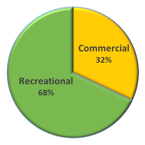
Harvest Limits
| Sector | 2023/2024 Annual Catch Limit |
| Stock | 9,990,000 pounds |
| Commercial | 3,196,800 pounds |
| Recreational | 6,793,200 pounds |
Allocation